 Atlas of China
Mianyang 绵阳Miányáng
Li Bai's boyhood country, from the Fu River plain to the Qiang hills
About Mianyang
Mianyang, one of Sichuan's largest cities, is a centre of electronics and scientific research on the Fu River in the north-west of the Sichuan Basin. The Tang poet Li Bai grew up near Jiangyou, where Li Bai's Former Residence, Qinglian and the iron chains strung between the rock peaks of Mount Douchuan draw visitors. Beichuan Qiang City and Earthquake Ruins preserves the county town destroyed in 2008 beside its rebuilt Qiang successor, and Qiqushan Temple in Zitong honours Wenchang, god of literature.
What to eat in Mianyang
- Mianyang rice noodles (绵阳米粉)
- Zitong crisp cakes (梓潼酥饼)
Listed sites in Mianyang
31 sites in Mianyang are on the official lists. Those with a page of their own link to it; the rest open as cards on the map.
- Beichuan Qiang City and Earthquake Ruins 北川羌城 5A scenic area
Beichuan, China's only Qiang autonomous county, was devastated by the 2008 Sichuan earthquake, and this area links the rebuilt county town at Yongchang with the memorial sites of the disaster. - Baishui Lake, Anzhou 白水湖 4A scenic area
A hill reservoir at Jushui in western Anzhou District, where 23 islands break up some 3,000 mu (about 2 km²) of water into inlets and channels. - Bao'en Temple, Pingwu 报恩寺 4A scenic area · National heritage site · on the map
Built between 1440 and 1446 by the local chieftain Wang Xi, this Buddhist monastery in Pingwu town is a remarkably well-preserved Ming complex whose timber frames are all of nanmu wood. - Foye Cave 佛爷洞 4A scenic area · on the map
A karst cave in Dakang town, north-west of Jiangyou, with chambers of stalactites, stalagmites and rimstone pools and an underground river toured by boat. - Li Bai Memorial Hall 李白纪念馆 4A scenic area · on the map
A museum and Tang-style garden beside the Changming River in Jiangyou, dedicated to the Tang poet Li Bai, who grew up nearby. - Li Bai's Former Residence, Qinglian 李白故居 4A scenic area · on the map
Qinglian is traditionally held to be the boyhood home of Li Bai, whose family is said to have settled here around 705, when he was about five. - Mianyang Science and Technology Museum 绵阳科技馆 4A scenic area · on the map
Mianyang's science museum reflects the city's role as China's 'Science City', home to the national nuclear weapons research academy, and is themed on the 'Two Bombs, One Satellite' programme. - Mount Douchuan and Yunyan Temple 窦圌山 4A scenic area · National heritage site
Mount Douchuan rises above the east bank of the Fu River north of Jiangyou, its bare rock summit peaks linked by suspended iron chains. - Mount Jiuhuang 九皇山 4A scenic area · on the map
A limestone mountain area in eastern Beichuan County known for the Ape King Cave and other karst caves. - Mount Luofu, Anzhou 罗浮山 4A scenic area · on the map
An isolated, steep and wooded hill in western Anzhou District, raised from an ancient seabed by tectonic movement, which in mist seems to float in the clouds. - Mount Xunlong 寻龙山 4A scenic area · on the map
A small scenic area of eroded conglomerate rock beside the new Beichuan county town, with rock forests, a waterfall and a cave explored by boat. - Qiqushan Temple 七曲山大庙 4A scenic area · National heritage site
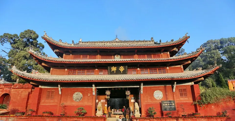
A Taoist temple complex on Qiqu Mountain just north of Zitong, founded as a shrine to the local deity Zhang Yazi and rebuilt as a Wenchang Palace after he was honoured as Wenchang, god of literature, in the early Yuan dynasty. - Two Bombs City 两弹城 4A scenic area · National heritage site · on the map
From 1969 to 1992 this compound at the foot of Changqing Mountain was the headquarters of the Ninth Academy, now the China Academy of Engineering Physics, the institute that developed China's nuclear weapons. - Weiste Agricultural Park, Beichuan 维斯特农业观光园 4A scenic area · on the map
A modern-farming showcase on the edge of Yongchang, the new Beichuan county town built after the 2008 earthquake. - Xianhai Lake, Mianyang 仙海 4A scenic area
A reservoir lake about 15 km east of central Mianyang, formed by the Chenkang Reservoir of the Wudu irrigation scheme and run as a national water-conservancy scenic area and 4A resort. - Yaowang Valley, Beichuan 药王谷 4A scenic area
A forested mountain valley in Beichuan run as a 4A wellness area themed on traditional Chinese medicine. - Yuewang Tower 越王楼 4A scenic area
The first Yuewang Tower was built on Gui Hill in 656 by Li Zhen, Prince of Yue and a son of Emperor Taizong, and was praised by poets including Du Fu before being destroyed and rebuilt several times. - Bishui Temple Cliff Carvings 碧水寺摩崖造像 National heritage site · on the map
About 25 Tang-dynasty Buddhist niches carved into the rock at Bishui Temple, on the east bank of the Fu River in central Mianyang. - Hualin Temple, Yanting 花林寺 National heritage site · on the map
The main hall of a former temple in Huoxing village, Fuyi town, in north-eastern Yanting County, originally called Doushuai Temple; ink inscriptions on its beams, read with infrared photography in 2015, date it to 1311 under the Yuan dynasty. - Kaixi Temple 开禧寺 National heritage site · on the map
A Buddhist temple in Tashui, in Anzhou district west of Mianyang, whose surviving buildings date mainly from the Ming dynasty. - Li Ye Que 李业阙 National heritage site
The single surviving pillar of the funerary que of Li Ye, an official who lived at the turn of the Western and Eastern Han, is thought to date from the start of the Eastern Han and is regarded as the earliest of China's surviving Han que. - Ma'an Temple 马鞍寺 National heritage site
A Qing-dynasty temple in Liujia town, in rural eastern Youxian district, Mianyang, whose buildings line up along a single axis: a two-storey opera tower of 1867, the Hall of the Heavenly Kings of 1702, the main hall of 1750, and Guanyin and Jade Emperor halls behind. - Pingyang Fujun Que 平阳府君阙 National heritage site · on the map
A rare surviving pair of Eastern Han stone que, ceremonial pillar-gates, standing about 27 m apart beside the Furong Stream in front of the new Mianyang Museum. - Qijiang Cliff Tombs 郪江崖墓群 National heritage site
The hills around Qijiang, an old town in southern Santai County on the site of the ancient state of Qi, hold a large group of Han-dynasty tombs cut into the cliffs, with more than 1,600 recorded. - Qinglinkou Old Town 青林口古镇 National heritage site
A small Qing-dynasty market town in the hills north-east of Jiangyou, on the Qingyun Creek near the Tong River. - Tongchuan City Wall 潼川古城墙 National heritage site · on the map
Santai was the seat of Tongchuan prefecture, and more than 2 km of its city wall survive. - Wenxing Temple, Yanting 文星庙 National heritage site · on the map
A Ming-dynasty temple in Exi village, in what is now Exi town in rural Yanting County, whose main hall carries beam inscriptions dated to the first year of the Longqing reign (1567). - Wolongshan Thousand Buddha Cliff 卧龙山千佛岩 National heritage site · on the map
A single boulder of white quartz sandstone carved on all four sides with Buddhist niches: rows of small 'thousand Buddha' niches on the south face and Buddha triads on the east and west faces. - Yuntai Taoist Temple 云台观 National heritage site
A large Taoist temple complex on Yuntai Mountain in southern Santai County, founded by a Taoist hermit early in the 13th century under the Southern Song. - Yuquan Temple 鱼泉寺 National heritage site · on the map
A rural temple in Dongxuan, in eastern Youxian district, Mianyang, whose main hall dates from the Ming dynasty and whose gate and other buildings, with carved timber bracket sets, are Qing. - Zunsheng Temple 尊胜寺 National heritage site · on the map
A Buddhist temple north-west of Santai town whose surviving buildings, centred on a timber main hall, date from the Ming and Qing dynasties.
On the map
Open Mianyang on the illustrated map to see its outline, its places and listed sites together, and to add them to a trip.
Open Mianyang on the map