 Atlas of China
Ordos 鄂尔多斯È’ěrduōsī
Singing dunes, Genghis Khan's shrine and a showpiece new city
- Type
- City
- Region
- Inner Mongolia
- Seat
- Dongsheng
- Featured places
- 1
- Listed sites
- 321 rated 5A · 27 rated 4A · 6 national heritage
About Ordos
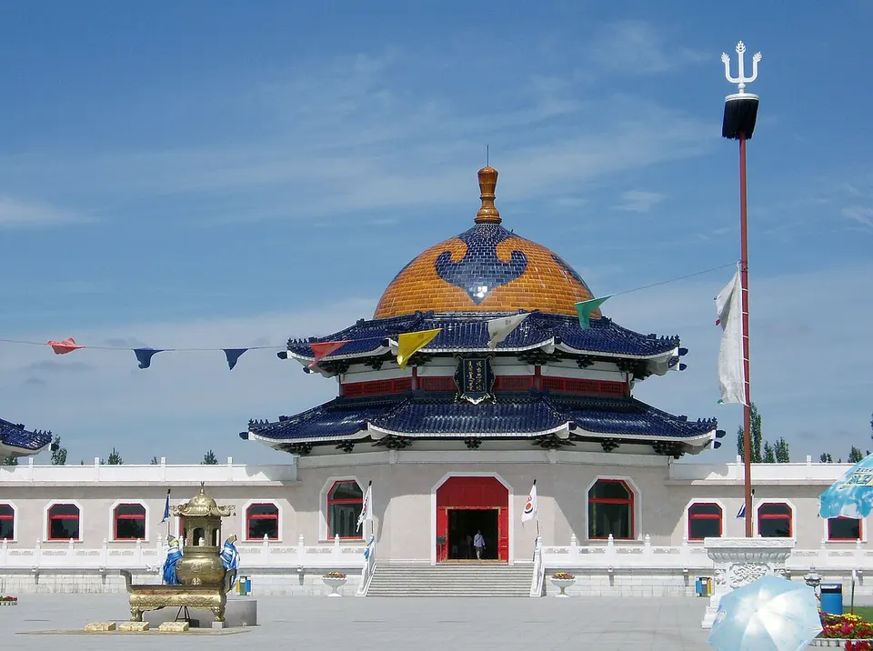
Ordos fills the northward loop of the Yellow River, with the Kubuqi Desert, whose dunes hum at Xiangshawan, along its northern edge and the Mu Us sandy land in the south. The Mausoleum of Genghis Khan, a Mongol-style shrine built in the mid-1950s, holds a cenotaph, since the Khan's burial place has never been found. Kangbashi, a planned district of squares and museums, houses the city government, and at Salawusu a human tooth identified in the 1920s became the emblem of 'Hetao Man'.
What to eat in Ordos
- Mongolian sheep banquet (羊宴)
Featured places in Ordos
-
Mausoleum of Genghis Khan 成吉思汗陵
A 1950s memorial to the Khan, where hereditary Darkhad guardians still keep the rites
Listed sites in Ordos
32 sites in Ordos are on the official lists. Those with a page of their own link to it; the rest open as cards on the map.
- Xiangshawan 响沙湾 5A scenic area
Xiangshawan is a desert resort at the eastern end of the Kubuqi Desert in Dalad Banner, known for dunes whose sand makes a humming sound when it slides. - Bulonghu Hot Spring Resort 布龙湖温泉度假区 4A scenic area · on the map
Bulonghu is a hot-spring and lake resort on the grassland of Otog Banner, beside the Bulong reservoir where the Dusitu River makes a wide bend. - Chengchuan Red Culture Tourism Area 城川红色文化旅游区 4A scenic area · on the map
Chengchuan in Otog Front Banner was part of a Communist-led base area in the 1940s, and the tourist area gathers its memorial sites: the Yan'an Nationalities Institute Chengchuan Memorial, a memorial to Yang Zao and Han Chun, whom the Ordos government calls international communist fighters, and the Wang Zhen Well memorial park. - Dashatou Desert Tourism Area 大沙头 4A scenic area · on the map
Dashatou is a desert sports and leisure resort in the Mu Us sandy land in Otog Front Banner. - Donglian Animation City 东联动漫城 4A scenic area · on the map
Donglian Animation City is a themed leisure and education complex in Hantai town, Dongsheng District, built around animated stories on moral education. - Engebei Ecological Tourism Area 恩格贝 4A scenic area · on the map
Engebei is an ecological demonstration area of about 300,000 mu (about 200 sq km) at the eastern end of the Kubuqi Desert, reclaimed from drifting sand through years of planting and development. - Ganlinwusu Lake Area 甘霖乌素 4A scenic area · on the map
Ganlinwusu is a lake-and-wetland tourist area in the Mu Us sandy land in southern Uxin Banner, where autumn brings large flocks of migrating birds to its lakes. - Jiuchenggong Resort 九城宫 4A scenic area · on the map
Jiuchenggong is a large resort of about 6 sq km in Hantai town, Dongsheng District, themed around Manhan culture, the blend of Mongolian and Han folk traditions of the Ordos area. - Jungar Yellow River Grand Canyon 准格尔黄河大峡谷 4A scenic area · on the map
In the south-east of Jungar Banner the Yellow River runs through a deep canyon along the Shanxi border, with villages, forts and river views strung along its bank. - Kangbashi Tourist Area 康巴什旅游区 4A scenic area · on the map
Kangbashi is the new urban district where the Ordos city government sits, and its core is rated as a tourist area made up of squares, themed parks and a city lake. - Kangzhen Grassland Silk Road Cultural Town 康镇草原丝路文化景区 4A scenic area · on the map
Kangzhen is a cultural-tourism town of about 3,500 mu in Kangbashi, built in the manner of buildings from regions along the grassland Silk Road. - Malanhua Grassland 马兰花草原 4A scenic area · on the map
Malanhua is a grassland resort in Otog Front Banner with a large performance stage, a racecourse, a Mongolian tribe-style village, a hotel named for the 38th parallel and a ceremonial oboo square. - Ordos Cashmere Industrial Tourism Area 鄂尔多斯羊绒工业旅游区 4A scenic area · on the map
This industrial-tourism area in Dongsheng District is the Ordos cashmere brand's production base, about 2,800 mu in size, with east and west plants, an office zone, living quarters and a research centre that houses the national cashmere products engineering research centre. - Ordos Cultural Industry Park 鄂尔多斯文化产业园 4A scenic area · on the map
The Ordos Cultural Industry Park is a development of 11.9 sq km near Altan Xire, the Ejin Horo Banner seat, built around film and television production, cultural exhibition and cultural tourism. - Ordos Grassland Tourism Area 鄂尔多斯草原旅游区 4A scenic area · on the map
This ger resort on the dry steppe of Hanggin Banner is arranged around two Mongolian golden tents and a camp of about 400 gers. - Ordos Racing Town 鄂尔多斯赛车小镇 4A scenic area · on the map
The town is built around the Ordos International Circuit, a track certified by the FIA at grade 2 that opened in 2010 and has hosted 79 national and regional events, including CTCC circuit-racing and CDGP drifting championship rounds and the long-running 'Warm City' (Nuancheng) race weekends. - Ordos Wildlife Park 鄂尔多斯野生动物园 4A scenic area · on the map
Ordos Wildlife Park covers about 12 km² of hills in Dongsheng district and opened in July 2012. - Qixinghu (Seven Star Lakes), Kubuqi Desert 库布其七星湖 4A scenic area · on the map
Qixinghu, 'Seven Star Lakes', is a lake-and-dune resort area in the heart of the Kubuqi Desert in Hanggin Banner, developed by the Elion Resources Group; its seven lakes are laid out like the Big Dipper. - Salawusu Site 萨拉乌苏遗址 4A scenic area · National heritage site · on the map
Salawusu is a Palaeolithic site along a 39 km canyon of the Salawusu River in the Mu Us Sandy Land, where Émile Licent found fossils in 1922 and excavated with Pierre Teilhard de Chardin in 1923; a human tooth from the finds became the emblem of 'Hetao Man'. - Shuijinghu Lake Resort 水镜湖 4A scenic area · on the map
Shuijinghu is a lakeside leisure-farming resort in the north of Jungar Banner. - Subohan Grassland Resort 苏泊罕草原 4A scenic area · on the map
Subohan is a grassland leisure resort in Subuerga town, Ejin Horo Banner, built around Mongolian herding life: guests stay in gers, ride horses, eat Mongolian meals and watch staged shows. - Uxin Zouma Culture Resort 乌审走马 4A scenic area · on the map
This resort in Suldesumu, Uxin Banner, was begun in 2006 on saline-alkali land that has since been restored as a wetland grassland within the Mu Us sandy land. - Wanjiahui Happy World 万家惠欢乐世界 4A scenic area · on the map
Wanjiahui Happy World is a large indoor leisure complex in Dongsheng District, with about 330,000 sq m of floor space. - Wantong Ecological Tourism Area 蒙根花万通生态旅游区 4A scenic area · on the map
A farm-based tourism area in Bainijing town, Dalad Banner, developed from the Wantong modern agriculture and livestock park. - Yihe Ecological and Cultural Expo Park 颐和生态文化博览园 4A scenic area · on the map
Yihe is a walled park in Ejin Horo Banner on the western edge of Kangbashi, begun in 2011 and built in Mongolian, Tibetan and Han styles, with 999 prayer wheels set in its circular outer wall. - Yinkentala Desert Oasis 银肯塔拉沙漠绿洲 4A scenic area · on the map
Yinkentala is a desert-and-grassland tourist park in Dalad Banner, on the south side of the Yellow River. - Yousongwang, the Pine King of Jungar 油松王 4A scenic area · on the map
Yousongwang, the 'Pine King', is a Chinese pine standing in Narisong town in the south of Jungar Banner. - Zhunge'er Zhao (Baotang Temple) 准格尔召 4A scenic area · National heritage site · on the map
Zhunge'er Zhao, formally Baotang Temple, is a Gelug-school Tibetan Buddhist monastery founded in 1623 and enlarged in the Kangxi and Qianlong reigns. - Alzhai Grottoes 阿尔寨石窟 National heritage site · on the map
The Alzhai Grottoes are a Buddhist cave temple on a hill in the steppe of Otog Banner, known in Chinese as Baiyanyao, 'Hundred-Eye Caves', and nicknamed the 'Dunhuang of the grassland'. - Chengchuan City Ruins 城川城址 National heritage site · on the map
Chengchuan City Ruins are the remains of a walled city north-east of Chengchuan town, which the Otog Front Banner government identifies as Jianing in Youzhou, a prefecture set up in 738 to settle Turkic and Sogdian groups from the Six Hu Prefectures. - Shartemtu Temple 沙日特莫图庙 National heritage site · on the map
Shartemtu is a Gelug-school Tibetan Buddhist monastery on the steppe of Hanggin Banner, also called Putiji'du Temple, first built in the early Ming and enlarged in 1862. - Zhaizigedan Site 寨子圪旦遗址 National heritage site · on the map
A Neolithic stone-walled settlement on a hilltop above the Yellow River in Jungar Banner, dating to about 5,000 years ago, between the Yangshao and Longshan cultures.
On the map
Open Ordos on the illustrated map to see its outline, its places and listed sites together, and to add them to a trip.
Open Ordos on the map