 Atlas of China
Longnan 陇南Lǒngnán
Green gorges south of the Qinling, with a Han inscription carved in a cliff
About Longnan
Longnan, between the Qinling and Min mountains in Gansu's far south-east, is wooded and mild enough to be called the 'Jiangnan of Gansu', its rivers draining to the Jialing. Its best-known sights are the forested gorges and waterfalls of Guan'egou, the karst halls of Wanxiang Cave and the Xixia Ode, a clerical-script inscription cut into a gorge wall west of Chengxian in AD 171. In Wen County the Baima, a group officially classed as Tibetan, keep wooden villages and masked New Year dances.
Listed sites in Longnan
27 sites in Longnan are on the official lists. Those with a page of their own link to it; the rest open as cards on the map.
- Guan'egou Scenic Area 官鹅沟 5A scenic area · on the map
Guan'egou is a set of forested gorges on the edge of Tanchang county town, where Guanzhu Gully, Eman Gully and Leigu Mountain are linked into one U-shaped circuit of about 66 km². - Bikou Old Town 碧口古镇 4A scenic area · on the map
Bikou is an old trading town on the Bailong River near the Sichuan border, long a landing where goods such as medicinal herbs were loaded for shipment downriver, and most of its merchants came from Sichuan, which gave it a Sichuan-flavoured dialect and a taste for Sichuan opera. - Chenyuan Eco-Park 陈院生态园 4A scenic area · on the map
An 8.7 km² rural leisure park in Chenyuan town, just west of Chengxian, laid out with orchards, woods and flower-lined roads. - Du Fu Thatched Cottage, Chengxian 杜公祠 4A scenic area · on the map
The Du Gong Shrine at the mouth of Feilong Gorge, south-east of Chengxian, commemorates the poet Du Fu, who stayed briefly at Tonggu, as the town was then called, in 759 before moving on to Chengdu; it is promoted as the earliest of China's many Du Fu 'thatched cottages'. - Gansu Qin Culture Museum 甘肃秦文化博物馆 4A scenic area · on the map
The Gansu Qin Culture Museum on Qinren Square in Li County town has a collection of several thousand objects, many recovered from the early Qin cemetery at Dabuzishan and the Xichui area. - Hadapu Long March Sites 哈达铺会议旧址 4A scenic area · National heritage site
Hadapu, a town on the old route between Sichuan and the north-west, is where Red Army columns on the Long March halted and reorganised in 1935, and where the Party leadership decided to head for the Communist base in northern Shaanxi. - Huaqiao Village, Kang County 花桥村 4A scenic area · on the map
Huaqiao is a village in Changba town, in the hills of western Kang County, that has been developed as a rural tourism area with countryside walks, holiday and retirement stays, folk-culture experiences including traditional liquor-making, and a centre where local farm produce is processed and sold. - Jialing River Gorges, Hui County 嘉陵江峡谷群 4A scenic area · on the map
A large scenic area of 217.6 km² along the gorges of the upper Jialing River in south-eastern Hui County, with cliffs, forest, caves and waterfalls, among them the Meiya Falls, which drop more than 400 m. - Jinhui Liquor Culture Park 金徽酒业 4A scenic area · on the map
The landscaped brewery park of Jinhui, a strong-aroma baijiu maker whose roots go back to a state distillery formed from local workshops in 1951, in Fujia town north-west of Hui County town. - Jinhui Mining Industrial Tourism Area 金徽矿业 4A scenic area · on the map
An industrial tourism site at Jinhui Mining's lead–zinc mine north of Hui County town, on the Xicheng lead–zinc belt. - Liangdang Mutiny Memorial Hall 两当兵变纪念馆 4A scenic area · on the map
This memorial hall in Liangdang county town commemorates the Liangdang Mutiny of 2 April 1932, when Xi Zhongxun and other Communist organisers led about 200 soldiers of a Nationalist battalion stationed in the area into revolt and reformed them as a Red Army guerrilla detachment, which was later broken up. - Qishan Fort and Wuhou Shrine 祁山堡 4A scenic area · on the map
The Qishan scenic area east of Li County town is built around Qishan Fort and its Wuhou Shrine to Zhuge Liang, one of the earliest shrines to him, rebuilt in the Ming and Qing dynasties, on the ground where Shu Han armies campaigned against Wei in the Three Kingdoms period. - Shanwan Menggu Valley 山湾梦谷 4A scenic area · on the map
A valley resort of about 240 ha in Lianghekou town, Tanchang, built around the Qiang and Tibetan culture of the area, with flower fields and farmland on the valley floor and forest above. - Wangba Rural Scenic Area, Kang County 王坝 4A scenic area · on the map
A rural scenic area of villages and wooded valleys around Wangba town, 10 km from Kang county town, centred on Dashuigou village, with a village-life exhibition hall, log-cabin lodgings and the cliffs of Qinglin Gully. - Wanxia Lake 晚霞湖 4A scenic area · on the map
Wanxia Lake is a reservoir lake of about 120 ha just west of Xihe county town, with reed beds, water birds and boat trips on the water. - Wanxiang Cave 万象洞 4A scenic area · on the map
A large karst cave on the south side of the Bailong River east of Wudu, filled with stalactites and other formations along the visitor route, whose walls carry inscriptions and poems left by visitors since the Northern Zhou. - Wenxian Tianchi Lake 文县天池 4A scenic area · on the map
Wenxian Tianchi, also called Yangtang Tianchi, is a long, winding mountain lake formed where faulting dammed the Yangtang River in the mountains north of Wen County, its shoreline broken by headlands and ringed by forested peaks. - Xixia Ode and Ancient Plank Road 西狭颂 4A scenic area · National heritage site · on the map
In the Tianjing Mountain gorge west of Chengxian, the Xixia Ode was cut into the cliff in AD 171 to praise Li Xi, governor of Wudu, for building a plank road through the gorge; its 385 characters of clerical script under a seal-script heading, beside a carved panel of five auspicious omens, make it one of the 'Three Odes of Han' prized by calligraphers. - Yangba Scenic Area 阳坝 4A scenic area · on the map
Yangba, in the far south of Kang County, is a humid, forested valley area of bamboo groves, streams, tea gardens and palms, promoted as the 'Xishuangbanna of Gansu' for its almost subtropical feel. - Yunhua Mountain 云华山 4A scenic area · on the map
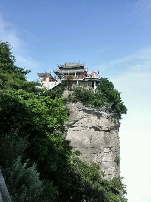
Yunhua Mountain, north-east of Xihe, is a steep danxia-type peak shaped like a jade tablet, which gave it the old name Guishan, with more than ten small Daoist temple halls, including one to the Xuanwu emperor, packed onto its narrow summit. - Yunping Three Gorges 云屏三峡 4A scenic area · on the map
The Yunping Three Gorges, Tudi, Guanyin and Xigou, cut through forested mountains south-east of Liangdang and form a provincial scenic area of cliffs, overhanging pines, waterfalls and caves with more than 60 named sights, among them a temple and two rock 'gates'. - Zhang Guolao Scenic Area, Liangdang 张果老养生文化景区 4A scenic area · on the map
A rural scenic area of about 320 ha in the hills of Yangdian town, north-east of Liangdang, built around the Guolao Dengzhen Cave, which legend links with the Daoist immortal Zhang Guolao. - Zhujiagou Old Village, Anmenkou 朱家沟古村 4A scenic area · on the map
Zhujiagou is an old village on the Yanzi River near Anmenkou town, listed as a Chinese traditional village in 2016, whose main sights are the Qing-style Zhu family compound, a covered 'wind-and-rain' bridge and an ancient Chinese wingnut tree said to be a thousand years old. - Dabuzishan Qin Royal Cemetery 大堡子山遗址 National heritage site
On the hills above the Western Han River east of Li County town lies the Dabuzishan cemetery of the early Qin lords at Xichui, the Qin people's first centre, with the earliest tombs of Qin rulers yet excavated. - Fujin Guangyan Temple 福津广严院 National heritage site · on the map
Fujin Guangyan Temple in Sanhe town, Wudu, is a Buddhist temple founded in the Song whose timber hall dates from the Southern Song, with Qing repairs. - Lichuan Brick Pagoda 栗川砖塔 National heritage site · on the map
A Northern Song brick pagoda, also called the Lichuan White Pagoda, in Xunzhuang village west of Hui County town, the surviving part of the White Pagoda Temple built in the Chunhua era (990–994). - New Baishui Road Cliff Inscription 新修白水路记摩崖 National heritage site · on the map
A Northern Song cliff inscription at Wangjiahe village south of Hui County town, recording in 883 characters of regular script, set out in 26 columns, how the Baishui road through these mountains was built and later rerouted.
On the map
Open Longnan on the illustrated map to see its outline, its places and listed sites together, and to add them to a trip.
Open Longnan on the map