 Atlas of China
Fan Lau Fort 分流炮台Fēnliú Pàotái
Declared monument · Hong Kong, Hong Kong
- Time needed
- Half a day
- Days to budget
- Half a day
- City
- Hong Kong
- Region
- Hong Kong
- Type
- Heritage
- Listed as
- Declared monument
About Fan Lau Fort
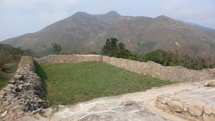
Fan Lau Fort is a small coastal fort of 1729 on the Fan Lau peninsula at the south-western tip of Lantau, looking out over the sea passage into the Pearl River estuary. The rectangular enclosure measures 46 m by 21 m, with walls of semi-dressed stone and green brick; it was probably abandoned around 1898, after the New Territories were leased to Britain, and was restored in the 1980s and 1990s. The peninsula is also known for the line where muddy river water meets clearer sea water.
How to get to Fan Lau Fort
On foot only, about 5 km south-west of the Sha Tsui bus stop at Shek Pik (New Lantao Bus routes 1, 2, 11 and 23), by way of Wang Pui Road, Lantau Trail sections 8 and 7 and the Fan Lau Country Trail. On 10 October 2025 the Agriculture, Fisheries and Conservation Department closed the Fan Lau Country Trail and part of Lantau Trail section 7 until further notice after typhoon and heavy-rain landslips, so check the current notice before planning.
Nearby
- Tian Tan Buddha & Ngong Ping 天坛大佛与昂坪 under 10 km
A giant bronze Buddha on Lantau, reached by a 25-minute cable car ride - Historic Centre of Macau 澳门历史城区 30 km
Portuguese tiled squares, baroque churches and Chinese temples, a short walk apart - Victoria Peak 太平山顶 30 km
Ride the 1888 funicular to the skyline view, then walk the Lugard Road loop - Victoria Harbour 维多利亚港 30 km
Glass towers and green hills around a harbour you can cross in ten minutes
Also within 20 km: Stone Circle at Fan Lau 分流石圆环 (under 10 km), Rock Carving at Shek Pik 石壁石刻 (under 10 km), Tai O Fishing Village 大澳渔村 (under 10 km), Yeung Hau Temple, Tai O 大澳杨侯古庙 (under 10 km), Guishan Island 桂山岛 (under 10 km), Po Lin Monastery 宝莲禅寺 (under 10 km).
On the map
Open Fan Lau Fort on the illustrated map to see the terrain around it and what else is close, and to add it to a trip.
Open Fan Lau Fort on the map