 Atlas of China
Dehong 德宏Déhóng
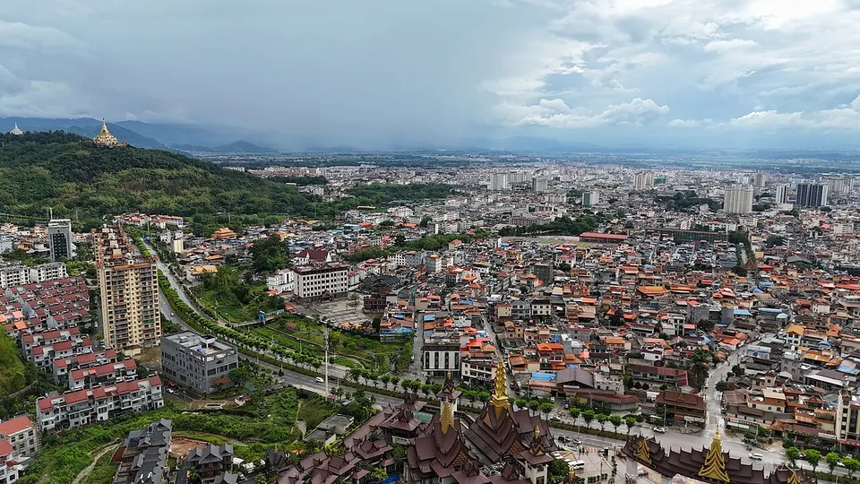
Golden pagodas, Jingpo dances and a village split by the Myanmar border
- Type
- Dai and Jingpo Autonomous Prefecture
- Region
- Yunnan
- Seat
- Mangshi
- Listed sites
- 97 rated 4A · 3 national heritage
About Dehong
Dehong reaches into Myanmar along warm, green river valleys, and two peoples give it its character: the Theravada Buddhist Dai, whose golden pagodas crown the hills around Mangshi, and the Jingpo, kin of Myanmar's Kachin, whose Munao Zongge dance festival is held around the Lantern Festival. Ruili is a busy border crossing, and near it a Dai village, One Village, Two Countries, is split by the frontier. In Lianghe, the Nandian Chieftain's Yamen recalls the hereditary chieftains who once ruled these valleys.
What to eat in Dehong
- Dai sapie (撒撇)
- Paoluda cold dessert (泡鲁达)
Listed sites in Dehong
9 sites in Dehong are on the official lists. Those with a page of their own link to it; the rest open as cards on the map.
- Mangshi Dai Ancient Town 芒市傣族古镇 4A scenic area
A Dai-style quarter built from 2019 on a hillside on the east side of central Mangshi and opened in 2020, with the Menghuan Palace, a hall styled on Dai Buddhist temple architecture, and lanes of restaurants, craft and costume shops and a hotel. - Mengbanaxi Rare Plant Garden 勐巴娜西珍奇园 4A scenic area · on the map
A garden park on the south-east side of central Mangshi, formerly the Mangshi Nationalities Cultural Palace, whose Dai name means 'a beautiful place'. - Menghuan Silver & Golden Pagodas 勐焕银塔 4A scenic area · on the map
A white Theravada Buddhist pagoda on Leiyarang hill above Peacock Lake in Mangshi, built as a counterpart to the Menghuan Golden Pagoda a few hundred metres away. - Moli Tropical Rainforest 莫里热带雨林 4A scenic area · on the map
A forested valley north-east of Ruili whose Dai name is said to mean 'beautiful waterfall'. - Nandian Chieftain's Yamen 南甸宣抚司署 4A scenic area · National heritage site
The headquarters of the Gong family, hereditary chieftains (tusi) of Nandian who ruled the area for about five centuries, in Zhedao, the county town of Lianghe. - One Village, Two Countries 一寨两国 4A scenic area · on the map
A Dai village south-west of Ruili where the China–Myanmar boundary runs through the settlement, so that the Chinese part is called Yinjing and the Myanmar part Mangxiu. - Peacock Valley, Mangshi 孔雀谷 4A scenic area · on the map
A forest park in the hills north-east of Mangshi where peacocks are bred and roam the grounds in large numbers, and flocks are released from the hillside in staged flights down into the valley. - Wanding Bridge 畹町桥 National heritage site
A short bridge over the Wanding River on the China–Myanmar border, first built in 1938 for the Burma Road; the present steel truss span was put up by Chinese and American forces in January 1945 after Japanese troops blew up its predecessor. - Yunyan Pagoda 允燕塔 National heritage site
A Dai Buddhist stupa complex on Yunyan hill at the edge of Yingjiang county town, commissioned in 1946 by the local chieftain Si Hongsheng and finished only in 1955–56 after delays caused by epidemic and war.
On the map
Open Dehong on the illustrated map to see its outline, its places and listed sites together, and to add them to a trip.
Open Dehong on the map