 Atlas of China
Qiandongnan 黔东南Qiándōngnán
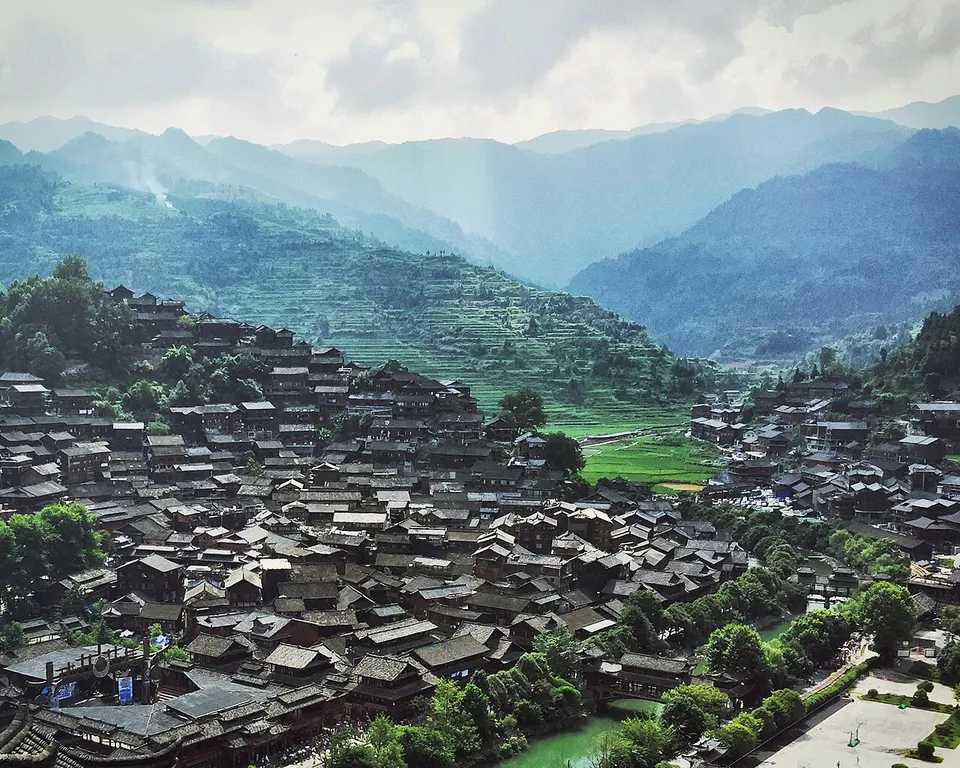
Miao silver, Dong drum towers and terraced valleys in the south-east
- Type
- Miao and Dong Autonomous Prefecture
- Region
- Guizhou
- Seat
- Kaili
- Featured places
- 2
- Listed sites
- 321 rated 5A · 18 rated 4A · 19 national heritage
About Qiandongnan
Qiandongnan is the heartland of Guizhou's Miao and Dong peoples. Xijiang, often described as China's largest Miao village, climbs its hillsides in tiers of wooden stilt houses, and Upper Langde has been kept as a village museum of Miao life since 1986, while in the south Dong villages such as Zhaoxing gather around drum towers and wind-and-rain bridges, where Dong Grand Song is sung. Zhenyuan Ancient Town lines a bend of the Wuyang River beneath the cliff temples of Qinglongdong.
What to eat in Qiandongnan
- Sour soup fish (酸汤鱼)
Featured places in Qiandongnan
-
Xijiang Miao Village 西江千户苗寨
More than a thousand wooden Miao homes climbing the hills, glittering like stars at night
-

Zhaoxing Dong Village 肇兴侗寨
Five drum towers and covered bridges in one of China's largest Dong villages
Listed sites in Qiandongnan
32 sites in Qiandongnan are on the official lists. Those with a page of their own link to it; the rest open as cards on the map.
- Zhenyuan Ancient Town 镇远古城 5A scenic area · National heritage site · on the map
Zhenyuan sits on an S-shaped bend of the Wuyang River, which divides the old prefectural city on the north bank from the old garrison city on the south bank, both built under the Ming. - Basha Miao Village 岜沙苗寨 4A scenic area · on the map
Basha is a Miao village a few kilometres from Congjiang county town, home to nearly 2,800 people, whose residents have kept customs such as haircuts with sickles, tree worship and carrying muskets with special permission from the police. - Danzhai Wanda Village 丹寨万达小镇 4A scenic area · on the map
Danzhai Wanda Village is a purpose-built tourism town beside Donghu lake in the middle of Danzhai county, built by the Wanda Group under a 2014 poverty-alleviation agreement with the county and opened in July 2017. - Gaoguo River, Zhenyuan 高过河 4A scenic area · on the map
Gaoguo River is a forested gorge river in Yangchang town, north-west of Zhenyuan, best known for summer rafting: a course of about 5 km that drops some 200 m past rapids, pools and waterfalls and takes three to four hours. - Guidong Scenic Area, Sansui 贵洞 4A scenic area · on the map
Guidong is a rural scenic area in Jieping village, Bagong town, centred on a karst cave that local sources describe as about 4 km long, with stalactites, grooves and an underground stream. - Jiabang Terraces 加榜梯田 4A scenic area · on the map
The Jiabang terraces climb the steep slopes of Jiabang township in southern Congjiang, covering more than 10,000 mu (about 667 ha) along some 25 km, with Miao villages scattered among the fields. - Jianhe Hot Spring Resort 剑河温泉 4A scenic area · on the map
A hot-spring resort in Wenquan village, Cengsong town, north-east of Jianhe county town, fed by six springs; the water comes out at about 38–53 °C and is a radon-and-sulphur type. - Jiuzhou Ancient Town, Huangping 旧州古城 4A scenic area · National heritage site · on the map
Jiuzhou is an old market town on the upper Wuyang River in Huangping county, long a trading and grain centre of eastern Guizhou. - Lanmenggu Blueberry Valley 蓝梦谷 4A scenic area · on the map
Lanmenggu is a blueberry-growing park in Longshan town, Majiang, one of two blueberry parks (with the nearby Wukaping park) in the county's blueberry tourism area. - Long'ao River Scenic Area 龙鳌河 4A scenic area · on the map
Long'ao River is a river valley in the north-west of Cengong county whose tourist stretch runs about 16.5 km, with gorges, waterfalls, caves and farmland. - Longli Ancient Town 隆里古城 4A scenic area · National heritage site · on the map
Longli is a walled garrison town founded under the Ming in the late 14th century, when soldiers and their families from Jiangnan and Jiangxi were settled here. - Lower Wuyang River, Zhenyuan 下舞阳河 4A scenic area · on the map
The lower Wuyang River runs from Gaobei Lake near Shibing down to Zhenyuan, within the Wuyang River national scenic area. - Qiaojie Old Street, Liping 翘街 4A scenic area · National heritage site · on the map
Qiaojie, literally 'upturned street', is an old street about 1 km long in the centre of Liping, named because its middle dips and both ends rise like a carrying pole. - Sanmentang Village 三门塘 4A scenic area · National heritage site · on the map
Sanmentang is a Dong village on the Qingshui River, close to the Hunan border, that was long a timber-trading port. - Shanmu River, Shibing 杉木河 4A scenic area · on the map
Shanmu River is a clear mountain river in the Shibing karst World Heritage area, inside the Wuyang River national scenic area, and one of the three main scenic areas of Shibing Karst. - Shidong Miao Town 施洞 4A scenic area · on the map
Shidong is a Miao market town on the middle Qingshui River, long a meeting place for the villages around it and a main venue for two festivals on China's national intangible-heritage list. - Upper Langde Miao Village 郎德上寨 4A scenic area · National heritage site · on the map
Upper Langde (Langde Shangzhai) is a Miao village of more than 100 households in Langde town, Leishan, set against a hillside and facing a stream, with the first houses dating from the late Yuan or early Ming. - Xiasi Ancient Town 下司古镇 4A scenic area · on the map
Xiasi is an old river town on the Qingshui River in Kaili, once a post station on a Tea-Horse trade route, and it still has a waterfront of old landing stages. - Yuntai Mountain, Shibing 云台山 4A scenic area · on the map
Yuntai Mountain, about 13 km north of Shibing, is the best-known part of Shibing Karst, inscribed in 2014 as part of the South China Karst World Heritage property. - Chong'an River Watermills 重安江水碾群 National heritage site · on the map
A row of traditional water-powered grain mills stands on a sandbar in the Chong'an River just south-east of Chong'an town in Huangping County, built from the Ming dynasty by local people influenced by the garrison settlers who brought new production methods from central China. - Dali Dong Village, Rongjiang 大利侗寨 National heritage site · on the map
Dali is a Dong village of about 300 households in Zaima township, Rongjiang County, whose old timber houses, five wind-and-rain bridges, stone-paved lanes, wells and drum tower are protected together as a national heritage group. - Diping Wind and Rain Bridge 地坪风雨桥 National heritage site · on the map
Diping Bridge crosses the Nanjiang River between the upper and lower Dong hamlets of Diping in the far south-east of Liping County, and was first built in 1882. - Feishan Temple, Jinping 飞山庙 National heritage site · on the map
Feishan Temple is a temple complex on the north bank of the Qingshui River in the old part of Jinping county town, built in 1769 in memory of Yang Zaisi, a local chief of the late Tang and Five Dynasties period. - Feiyunya Ancient Buildings, Huangping 飞云崖 National heritage site · on the map
Feiyunya is a temple-and-garden complex on a wooded hillside north-east of Huangping, centred on Yuetan Temple, which was founded in 1443 under the Ming. - Former Heping Village, Zhenyuan 和平村旧址 National heritage site
The former Heping Village is a walled compound on Heping Street in Zhenyuan's old town, once a Qing garrison office and then a prison, that served as a camp for Japanese prisoners of war held by the Nationalist government from 1938 to 1944. - Gaoqian Drum Tower 高阡鼓楼 National heritage site · on the map
Gaoqian Drum Tower stands in the Zaiyang hamlet of Gaoqian village, Xiajiang town, Congjiang County, and was built in the Yongzheng reign (1723–35), with repairs between the Jiaqing and Guangxu reigns and again in 1983. - Jingou Wind and Rain Bridge 金勾风雨桥 National heritage site · on the map
Jingou Wind and Rain Bridge is a covered timber bridge over a small stream at Jingou hamlet, Zengying village, in Wangdong town, Congjiang County. - Qinglongdong Ancient Architectural Complex 青龙洞 National heritage site
Qinglongdong (Qinglong Cave) is a group of Buddhist, Daoist and Confucian buildings built into a cliff of Zhonghe Mountain above the Wuyang River at the eastern end of Zhenyuan's old town, begun in 1388 and taking its present form by the early Qing. - Shudong Single-Pillar Drum Tower 述洞独柱鼓楼 National heritage site · on the map
The Shudong drum tower stands in the middle of the lower hamlet of Shudong village, Yandong town, Liping County, and is known as the single-pillar drum tower (it is also called the fir-tree tower) because its frame is built around one pillar running the full height of the tower. - Yanmen Zhangguansi Walled Town 岩门长官司城 National heritage site · on the map
Yanmen is a small walled stone town on the north bank of the Qingshui River in Gulong town, Huangping County, built as the seat of a hereditary native chieftain (zhangguansi) under the Ming and Qing. - Zai'e Drum Tower 宰俄鼓楼 National heritage site · on the map
Zai'e Drum Tower stands in the Dong hamlet of Zai'e, part of Gaoqian village in Xiajiang town, Congjiang County. - Zengchong Drum Tower 增冲鼓楼 National heritage site · on the map
Zengchong Drum Tower stands at the centre of the Dong village of Zengchong in Wangdong town, Congjiang County, and dates from the early Qing dynasty, with stone tablets beside it, the earliest dated 1672.
On the map
Open Qiandongnan on the illustrated map to see its outline, its places and listed sites together, and to add them to a trip.
Open Qiandongnan on the map