 Atlas of China
Bijie 毕节Bìjié
Wild rhododendron forests, a vast show cave and the high Yi uplands
About Bijie
Bijie spans Guizhou's high north-west, upland farming country where Yi, Hui and Miao communities live around Weining. In spring the Baili Dujuan Rhododendron Forest blooms with more than 60 wild species, and Zhijin Cave, explored for some 13.5 km, leads visitors through vast karst halls. On the Hezhang plateau the wild chives of Dajiucaiping flower purple in late summer, while Jiming Sansheng looks over the gorge where Guizhou, Yunnan and Sichuan meet.
Listed sites in Bijie
18 sites in Bijie are on the official lists. Those with a page of their own link to it; the rest open as cards on the map.
- Baili Dujuan Rhododendron Forest 百里杜鹃 5A scenic area
Baili Dujuan is a mountain forest of wild rhododendrons on the Bijie plateau, with more than 60 species recorded and, according to the Bijie government, a thousand-year-old azalea 'king' among the trees. - Zhijin Cave 织金洞 5A scenic area
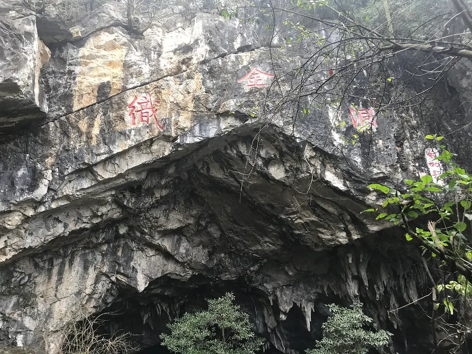
Zhijin Cave is a large karst show cave in the hills north-east of Zhijin town, known locally as Daji Cave until a county tourism survey team explored it in 1980. - Axilixi Grassland (Ertaipo) 阿西里西大草原 4A scenic area · on the map
Axilixi Grassland, also called Ertaipo, is a plateau of pasture in southern Hezhang at an average height of about 2,300 m, where cattle and horses graze beneath wide views and, in fair weather, seas of cloud. - Dajiucaiping (Hezhang side) 大韭菜坪 4A scenic area · on the map
Dajiucaiping ('big chive plateau') is a high plateau in south-western Hezhang between about 2,300 and 2,777 m, covered in wild chive plants whose purple flowers open from July and peak in August and September. - Fangjiaping Scenic Area 方家坪 4A scenic area · on the map
Fangjiaping is a mountain park in the Baili Dujuan district built around outdoor activities rather than flowers. - Gonglongping National Forest Park 拱拢坪国家森林公园 4A scenic area · on the map
Gonglongping is a forest park of more than 1,700 hectares in the hills near Bijie, with forest cover that Bijie's government puts at 95 per cent. - Jiming Sansheng 鸡鸣三省 4A scenic area · on the map
Jiming Sansheng ('cockcrow in three provinces') is a border village where Guizhou, Yunnan and Sichuan meet, named for the saying that a cock's crow here is heard in all three. - Jinhai Lake 金海湖 4A scenic area · on the map
Jinhai Lake is a lakeside and wetland park on the edge of the Jinhaihu New Area, between Bijie's Qixingguan District and Dafang, with more than 1,200 mu (about 80 hectares) of water. - Jiudongtian 九洞天 4A scenic area · on the map
Jiudongtian is a stretch of the upper Wu River system, known here as the Zongxi River, that runs through a chain of karst caves open to the sky through collapsed roofs, on the boundary of Dafang and Nayong counties. - Mu'ege Ancient City and Shexiang Tomb 慕俄格古城 4A scenic area · National heritage site · on the map
Mu'ege is a Yi name meaning the place where a ruler lives, and it was the seat of the Yi rulers of the Shuixi region, now Dafang; the 'ancient city' here is a reconstruction begun in 2008 on the old site. - Shexiang Ancient Town 奢香古镇 4A scenic area · on the map
Shexiang Ancient Town is a newly built district in the north of Dafang, developed mainly as a poverty-relocation project for about 12,000 residents. - Yishan Flower Valley 彝山花谷 4A scenic area · on the map
Yishan Flower Valley is a planted flower garden beside Pengcheng, the main town of the Baili Dujuan district, made to give visitors something to see after the rhododendron season ends. - Youshanhe 油杉河 4A scenic area · on the map
Youshanhe is a karst gorge and forest scenic area of about 67 sq km in north-eastern Dafang, one mountain range away from Baili Dujuan. - Zhongguohe Rafting Resort 中果河 4A scenic area · on the map
Zhongguohe is a rafting resort on the Zhongguohe river in Zhongjian township, Qianxi, whose rafting course and themed viewpoints follow the 1990s film A Chinese Odyssey (Dahua Xiyou), with spots named after scenes in it such as the Moonlight Box and Dinosaur Valley. - Datun Tusi Manor 大屯土司庄园 National heritage site · on the map
Datun Tusi Manor is a walled hillside residence and administrative seat of a Yi tusi family, a hereditary local chieftain under imperial rule, built up from the Qing dynasty to the early Republic. - Guanyindong Palaeolithic Site 黔西观音洞遗址 National heritage site · on the map
Guanyindong is a cave in Guanyindong village, Qianxi, where excavations from the 1960s uncovered more than 3,000 stone tools and the bones of 23 mammal species, among them giant panda and rhinoceros. - Old Buildings of Zhijin 织金古建筑群 National heritage site · on the map
Zhijin's old town, founded in 1666 and named among Guizhou's four early historic cities, holds a group of 25 listed heritage points, among them the Caishen and Heishen temples and seven old bridges, dating from the Yuan to the Qing dynasty. - Sichuan–Yunnan–Guizhou Revolutionary Committee Site 川滇黔省革命委员会旧址 National heritage site · on the map
This former church compound in central Bijie served as the office of the Sichuan–Yunnan–Guizhou Provincial Revolutionary Committee, set up by the Red Army's 2nd and 6th Army Groups in February 1936.
On the map
Open Bijie on the illustrated map to see its outline, its places and listed sites together, and to add them to a trip.
Open Bijie on the map