 Atlas of China
Chongzuo 崇左Chóngzuǒ
Red cliff paintings, rare white-headed langurs and a waterfall on the frontier
About Chongzuo
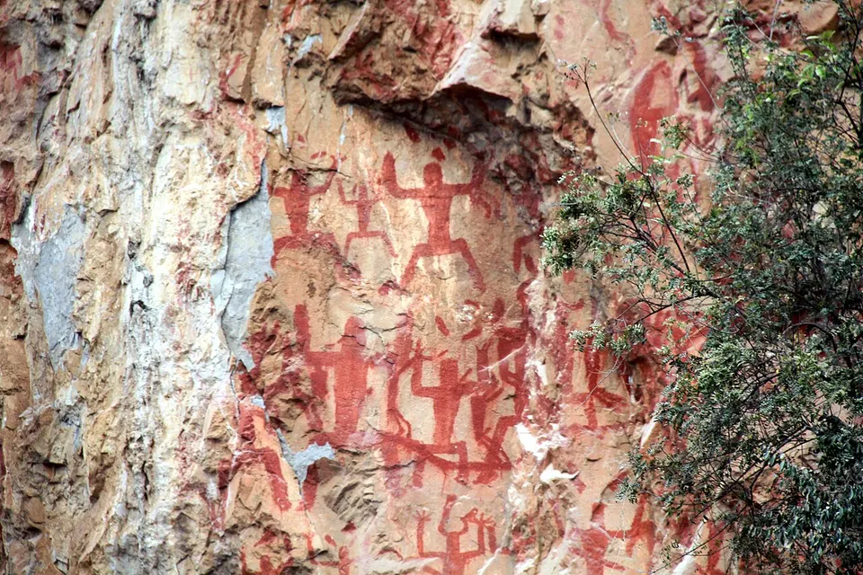
Chongzuo is an old heartland of Zhuang culture, where more than eight in ten people are Zhuang and sugar cane grows among karst hills along the Zuo River. On cliffs above the Ming River, red figures painted around 2,000 years ago form the Zuojiang Huashan Rock Art, a UNESCO World Heritage Site since 2016. Detian Waterfall spills over a river on the border with Vietnam, the old gate of Friendship Pass stands at Pingxiang, and karst forests shelter the rare white-headed langur.
Featured places in Chongzuo
-
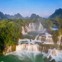
Detian Waterfall 德天瀑布
A broad, tiered waterfall spilling across the border between China and Vietnam
-
Zuojiang Huashan Rock Art 花山岩画
About 1,900 red figures painted on a sheer cliff above the Ming River
Listed sites in Chongzuo
22 sites in Chongzuo are on the official lists. Those with a page of their own link to it; the rest open as cards on the map.
- China (Nanning) Leyang City 中国(南宁)乐养城 4A scenic area · on the map
A wellness and retirement-living resort town in Fusui County, planned from 2010 and opened in stages from 2022, laid out around a lake with landscaped grounds. - Daliancheng Fortress 大连城 4A scenic area · on the map
After 1885 the Guangxi military commander Su Yuanchun made this ring of hills just north of Pingxiang his frontier headquarters, linking the peaks with walls, blockhouses and eight hilltop gun batteries and closing the passes with four gates over nearly two decades of building. - Discover Nonggang Scenic Area 发现弄岗 4A scenic area · on the map
An ecotourism area developed from 2018 at Siqing village, Xiangshui township, beside the Nonggang National Nature Reserve, whose karst hills carry seasonal rainforest and are home to rare langurs and birds. - Dongna Yuwan (Anping Xianhe) 峒那屿湾 4A scenic area · on the map
A stretch of karst river scenery on the Heishui River at Anping village, Leiping, formerly marketed as Anping Xianhe and also a national wetland park. - Friendship Pass 友谊关 4A scenic area · National heritage site
Friendship Pass is the historic gateway on the China–Vietnam border south-west of Pingxiang, known as Zhennan Pass until 1953 and given its present name in 1965. - Lichuan Cultural Forest Park 丽川文化森林公园 4A scenic area · on the map
A forest park on the edge of Tiandeng county town, registered as a regional-level forest park and upgraded to a 4A scenic area in 2019. - Litun Tianmeng Scenic Area 立屯天梦 4A scenic area · on the map
A memorial and study-tour site at Litun, a hamlet in the karst hills of Tuokan township whose villagers spent 24 years cutting a tunnel through the mountain to the outside world. - Longgong Cave (Longgong Xianjing) 龙宫仙境 4A scenic area · on the map
A large natural limestone cave at Naling, near Daxin, with lofty chambers of stalactites, stalagmite columns and pools, lit with coloured lights along the visitor route. - Longguwan Dinosaur Park 龙谷湾恐龙公园 4A scenic area · on the map
A dinosaur-themed amusement park near Fusui that opened in 2017, themed on the 'nest of three dinosaurs' fossil find in Fusui County, with recreated dinosaurs and other prehistoric animals, rides and play areas. - Longzhou Red Army Trail and Tianqin Zhuang Village 龙州红军古道 4A scenic area · on the map
An old horse-caravan path of about 2 km over the hills between Shuilong and Fucha hamlets, once the main route from Longzhou towards Jingxi and Baise, which, according to the local account, Deng Xiaoping travelled several times in 1929 while organising the Baise and Longzhou uprisings. - Longzhou Uprising Memorial Park 龙州起义纪念园 4A scenic area · on the map
The memorial park centres on the Longzhou Uprising Memorial Hall, opened in 2004 as the new exhibition building of the Eighth Red Army memorial museum, which covers the uprising of February 1930 in which Communist-led troops under Yu Zuoyu, Li Mingrui and Deng Xiaoping formed the Eighth Red Army and a short-lived soviet along the Zuo River. - Mingshi Pastoral Scenery 明仕田园 4A scenic area · on the map
The valley of the Mingshi River in Kanxu township, where the river winds between rice fields and steep karst peaks dotted with Zhuang villages. - Paiyangshan Forest Park 派阳山森林公园 4A scenic area · on the map
A forest park of about 1,340 hectares on a state forest farm in Ningming County, covered in Tongmian pine and star-anise plantations with clear streams running through the valleys. - Pingxiang Rosewood Culture Expo City 红木文博城 4A scenic area · on the map
A large trade and exhibition complex in southern Pingxiang devoted to hongmu (rosewood) furniture, with showroom halls where hundreds of furniture firms display their work, a shopping street and buildings in traditional Chinese style. - Shijinglin Stone Forest and Chongzuo Garden Expo Park 石景林·园博园 4A scenic area · on the map
Two adjoining parks in Chongzuo's southern new district: Shijinglin, a karst 'stone forest' of about 100 hectares opened in 1991, with weathered limestone pinnacles, small caves and pools named after the shapes they suggest, and the landscaped grounds built for the 7th Guangxi Garden and Horticulture Expo. - Taiping Ancient Town 太平古城 4A scenic area · on the map
A leisure and shopping district in central Chongzuo built around the site of Taiping prefecture's city wall, first raised in 1372 under the Ming and now partly repaired, with a restored inner waterway. - White-headed Langur Ecotourism Area 白头叶猴生态旅游区 4A scenic area · on the map
A visitor area on the edge of the Banli section of the Chongzuo White-headed Langur National Nature Reserve, which protects the critically endangered white-headed langur, a blackish monkey with a white crown, cheeks and neck found only in the karst hills of south-west Guangxi. - Xiaoliancheng Fortress (Jiangshan Forts) 小连城 4A scenic area · on the map
A hill fortress near Longzhou, also called the Jiangshan forts, built from 1886 by the Guangxi military commander Su Yuanchun as the command centre of the frontier defences facing French-ruled Vietnam. - Yuhuashi Scenic Area 雨花石景区 4A scenic area · on the map
An area of about 3 km² on a bend of the Zuo River where countless coloured pebbles are cemented into rounded, many-hued conglomerate outcrops and cliffs, an unusual rock landscape for the region. - Zuojiang Leaning Tower 左江斜塔 4A scenic area · National heritage site · on the map
A five-storey octagonal brick pagoda, also called Guilong Pagoda, standing on a rocky islet in the Zuo River just outside central Chongzuo. - Former French Consulate, Longzhou 法国驻龙州领事馆旧址 National heritage site · on the map
Two matching two-storey French-style buildings in Longzhou, ringed by verandas behind 20 tall arches, with stone floors and spiral stairs of ironwood. - Ho Chi Minh Exhibition Hall, Longzhou 胡志明展馆 National heritage site · on the map
A late-Qing house at 99 South Street in Longzhou that served as the secret office of the Communist Party of Vietnam, at a time when the town was a main base abroad for Ho Chi Minh and other Vietnamese revolutionaries.
On the map
Open Chongzuo on the illustrated map to see its outline, its places and listed sites together, and to add them to a trip.
Open Chongzuo on the map