 Atlas of China
Huainan 淮南Huáinán
The legendary birthplace of tofu and the last capital of the state of Chu
About Huainan
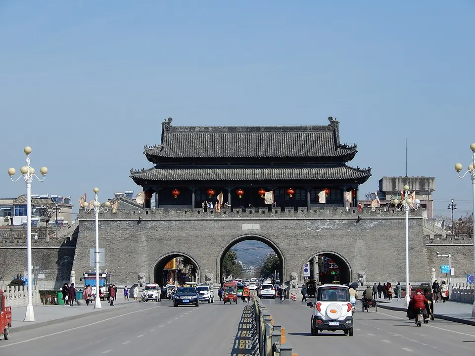
Huainan is a coal and power city on the south bank of the Huai River, but its history lies west in Shou County. There the walled town of Shouchun became the last capital of Chu in 241 BC, and its Southern Song walls still keep all four gates and their barbicans. In the Bagong Mountain hills to the north, legend says, the Han prince Liu An, patron of the Huainanzi, invented tofu, and the Battle of Fei River was fought nearby in 383.
What to eat in Huainan
- Huainan beef soup (淮南牛肉汤)
- Bagong Mountain tofu (八公山豆腐)
Listed sites in Huainan
11 sites in Huainan are on the official lists. Those with a page of their own link to it; the rest open as cards on the map.
- Anhui Chu Culture Museum (Shou County Museum) 安徽楚文化博物馆 4A scenic area · National heritage site · on the map
Shou County's museum, founded in 1958, reopened in 2022 in a new 15,000 m² building as the Anhui Chu Culture Museum, inside the Shouchun City National Archaeological Site Park on the site of the capital the state of Chu moved to in 241 BC. - Bagong Mountain Scenic Area 八公山 4A scenic area
A range of some 40 low peaks between Huainan and Shou County, named after the 'Eight Gentlemen' of the Western Han prince Liu An, who compiled the Huainanzi here and, by legend, invented tofu; the Battle of Fei River of 383 was fought below them. - Jiaogang Lake Film and Television Base 焦岗湖影视城 4A scenic area · on the map
A large outdoor film set beside Jiaogang Lake, built as a backlot of walled mansions, farm courtyards, an old railway station and locomotive, trenches, an old hospital, a people's commune hall and dormitories for 'sent-down' youth. - Jiaogang Lake National Wetland Park 焦岗湖 4A scenic area · on the map
A lake of about 40 km² on the north side of the Huai River in Huainan's Maoji district, cut off from the river by embankments in the 1950s and now a national wetland park and water-conservancy scenic area. - Longhu Park, Huainan 龙湖公园 4A scenic area · on the map
Huainan's oldest public park, laid out around a lake in Tianjia'an District from 1957 and opened in 1980. - Shangyao National Forest Park 上窑国家森林公园 4A scenic area · on the map
A national forest park of about 30 wooded hills and 10.4 km² in Huainan's Datong District, near Shangyao town, one of the centres of the Tang-dynasty Shouzhou kilns. - Shou County Old Town and City Wall 寿县古城 4A scenic area · National heritage site
Shou County's old town, the Shouchun of history and the last capital of the state of Chu, is still ringed by its city wall, rebuilt in the Southern Song with bricks stamped 'Jiankang' that can still be seen. - Anfengtang Reservoir (Quebei) 安丰塘 National heritage site
Anfengtang, known in antiquity as Quebei, is an irrigation reservoir in southern Shou County that tradition attributes to Sunshu Ao, chief minister of the state of Chu in the Spring and Autumn period, although some scholars argue it is no older than the Han. - Datong Wanrenkeng Memorial Hall (Huainan Japanese Occupation Sites) 大通万人坑教育馆 National heritage site
A memorial hall in Huainan's Datong coal-mining district built at the Wanrenkeng ('ten-thousand-person pits'), three trenches on the northern foot of Shungeng Mountain that hold the remains of more than 10,000 miners and resistance fighters who died under the Japanese occupation of the Datong mines. - Shou County Confucius Temple 寿县孔庙 National heritage site · on the map
The Confucian temple of Shou County stands on West Street inside the walled old town, a complex of Ming and Qing buildings that includes the Dacheng Hall and a Kuixing Pavilion, with old ginkgo trees in its courtyards. - Shou County Mosque 寿县清真寺 National heritage site · on the map
A mosque in Qingzhensi ('Mosque') Lane inside the walled old town of Shou County, whose surviving buildings date from the Ming and Qing dynasties.
On the map
Open Huainan on the illustrated map to see its outline, its places and listed sites together, and to add them to a trip.
Open Huainan on the map