 Atlas of China
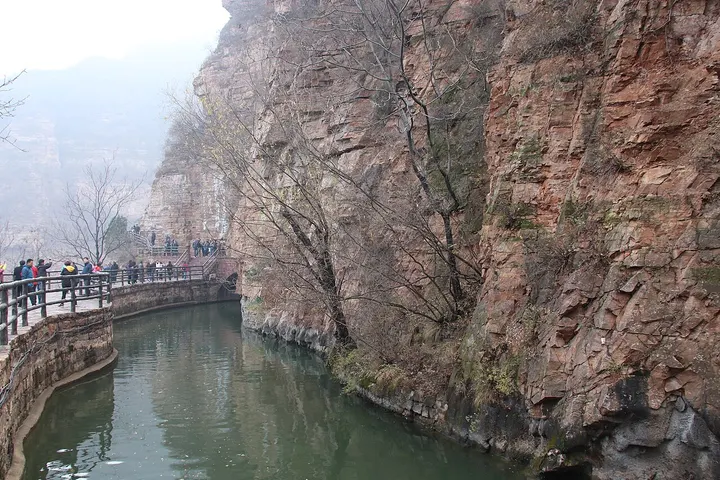
Red Flag Canal 红旗渠Hóngqí Qú
5A scenic area · National heritage site · Anyang, Henan
- Time needed
- Half a day to 1 day
- Days to budget
- 1 day
- City
- Anyang
- Region
- Henan
- Type
- Heritage
- Listed as
- 5A scenic area, National heritage site
About Red Flag Canal
An irrigation canal cut along the cliffs of the Taihang Mountains by the people of Lin County (now Linzhou) between 1960 and 1969 to bring water from the Zhang River; the trunk canal is 70.6 km long and the whole network of branches about 1,500 km. The work cut 211 tunnels and built 151 aqueducts, and official reports put the death toll at 81. Visitors walk cliff-side stretches of the channel and see the Red Flag Canal Memorial Hall at Fenshuiling, where the trunk canal divides into three main branches; the hall, reopened in its present form in 2014, tells the story of the construction with about 320 photographs and more than 1,100 objects.
How to get to Red Flag Canal
The memorial hall at Fenshuiling is about 20 km north of central Linzhou, some 30 minutes by car, and Linzhou is about an hour by road west of Anyang; together with the Taihang Grand Canyon the canal forms one 5A scenic area.
Nearby
- Taihang Grand Canyon 太行山大峡谷 40 km
Sheer gorges in the Taihang Mountains, explored by boat, cliff path and cable car - Yinxu 殷墟 50 km
The last Shang capital, where China's earliest writing and Fu Hao's tomb came to light - Wanxian Mountain (Guoliang) 万仙山 60 km
A village that hand-cut a road through the cliff face
Also within 20 km: Taihang Grand Canyon 太行大峡谷 (10 km), Pagoda of Master Minghui 明惠大师塔 (20 km), Xiuding Temple Pagoda 修定寺塔 (20 km), Tianji Mountain 天脊山 (20 km), Tongtian Gorge 通天峡 (20 km), Chinese Ancient Chestnut Park 中华古板栗园 (20 km).
On the map
Open Red Flag Canal on the illustrated map to see the terrain around it and what else is close, and to add it to a trip.
Open Red Flag Canal on the map