 Atlas of China
Hanzhong Rapeseed Fields 汉中油菜花Hànzhōng Yóucàihuā
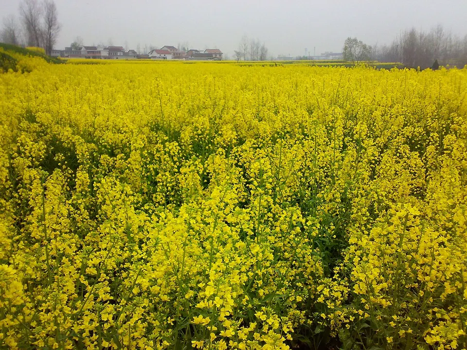
Spring rapeseed turning the Han River basin gold beneath the Qinling foothills
- Best time
- Mar–early Apr
- Time needed
- 1 day
- Days to budget
- 1 day
- Stay in
- Hanzhong
- Region
- Shaanxi
- Type
- Nature
Why go to Hanzhong Rapeseed Fields
Each spring the Hanzhong Basin, a long plain on the upper Han River between the Qinling and Daba mountains, turns yellow as about a million mu (some 67,000 hectares) of rapeseed comes into flower. Start at Huangtang Water Town in Laojun Town, on the northern edge of Hanzhong city, one of the busiest viewing areas, where a small sightseeing train runs through the fields. With a car, follow the official flower routes on into the basin's counties.
The story
Hanzhong gave its name to the Han dynasty. After the fall of the Qin, Liu Bang was made King of Han, with Hanzhong as his base, and when he defeated his rival Xiang Yu he kept the name for his new dynasty, which in turn gave its name to the Han Chinese.
What to see at Hanzhong Rapeseed Fields
- Huangtang Water Town 黄塘水乡: The best-known viewing area in the basin, in Laojun Town on the north side of Hanzhong city: a small sightseeing train runs through the fields, with a flower market and performances in season.
- Chen Village, Yangchun Town 阳春镇陈村: A village in Nanzheng District where the flowers spread over the surrounding fields; one of the spots Xinhua photographers covered in the 2026 bloom.
- Gaotuba, Yanghe Town 杨河镇高土坝: A flower-viewing area in Xixiang County, one of the places the city lists along its official flower routes.
How to visit Hanzhong Rapeseed Fields
Start at Huangtang, a short ride north of Hanzhong station, where trains and boardwalks make the flowers easy to see in a couple of hours. For the rest of the basin, hire a car and follow the official flower routes, of which the city lists 15 for a recent bloom. A full day covers Huangtang plus one or two of the other routes.
How to get to Hanzhong Rapeseed Fields
High-speed trains from Xi'an North reach Hanzhong in about 1–1.5 hours. Huangtang is a short taxi ride north of Hanzhong station; for the routes through Yang, Chenggu and Mian counties, hire a car with a driver.
Where to stay
Stay in Hanzhong city, which has the high-speed station and is close to Huangtang and the other flower routes in the basin.
What to eat
- Hanzhong hot rice-skin noodles 汉中热米皮: Steamed rice-batter sheets cut into strips and dressed with chilli oil, vinegar and soy, a signature dish of Hanzhong.
- Hanzhong vegetable tofu 汉中菜豆腐: Soft tofu made by setting soy milk with the sour liquid of fermented vegetables, served with chilli oil and garlic.
Tips for visiting Hanzhong Rapeseed Fields
- Bloom dates shift with the weather from year to year: the basin floor flowers first and the hills up to a couple of weeks later, with the peak usually in mid- to late March, so check current reports before you go.
- Huangtang drew more than 40,000 visitors on a single day in March 2026, so arrive early, and note that the spring festival's main venue moves between counties from year to year.
- In Yang County, east of the city, photographers wait at villages such as Caoba for crested ibises feeding beside the flowering fields; in 1981 the only seven known wild birds were found in this county.
Nearby
- Mount Taibai 太白山 110 km
Forest roads and a cable car climb to 3,511 metres on the Qinling range's highest peak
Also within 30 km: Xinghan Shengjing 兴汉胜境 (under 10 km), Hanzhong Museum (Gu Hantai) 汉中市博物馆 (under 10 km), Shimen Plank Road Scenic Area 石门栈道 (10 km), Tomb of Zhang Qian 张骞墓 (20 km), Wumen Weir 五门堰 (20 km), Former Site of National Northwest Associated University 国立西北联合大学旧址 (30 km).
On the map
Open Hanzhong Rapeseed Fields on the illustrated map to see the terrain around it, what else is close, and to add it to a trip and plan the days.
Open Hanzhong Rapeseed Fields on the map