 Atlas of China
Dunhuang Yardang National Geopark 敦煌雅丹国家地质公园Dūnhuáng Yǎdān Guójiā Dìzhì Gōngyuán
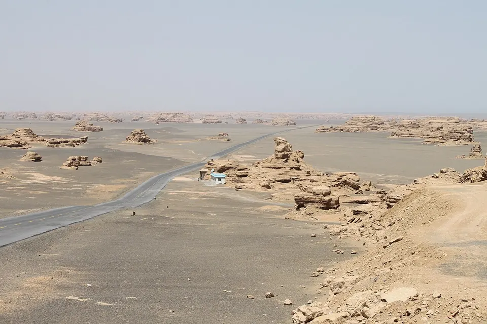
Wind-carved clay towers stretching to the horizon in the Gobi beyond Yumen Pass
- Best time
- Apr–Jun, Sep–Oct
- Time needed
- A full day
- Days to budget
- 1 day
- Stay in
- Dunhuang
- Region
- Gansu
- Type
- Nature
- Listed as
- 4A scenic area
Why go to Dunhuang Yardang National Geopark
Far northwest of Dunhuang, the wind has carved the Gobi into a maze of long clay ridges and towers called yardangs, covering around 400 km² in northern and southern zones. Locals call it the Ghost Town for the way the formations loom like ruined buildings and the wind howls through them. The national geopark is part of the Dunhuang UNESCO Global Geopark, approved in 2015, and the late-afternoon light on the formations is hard to beat.
The story
Yardang is a Turkic word for steep, wind-eroded ridges, and these took shape over hundreds of thousands of years as the wind scoured the softer layers from the desert floor. Many are named for what they look like, including a golden lion, a peacock, a sphinx and a fleet of ships.
What to see at Dunhuang Yardang National Geopark
- Gold Lion Greeting Guests 金狮迎客: One of the park's best-known formations, a ridge shaped like a lion; the shuttle makes a stop here.
- Sphinx 狮身人面像: A yardang whose outline resembles the Egyptian sphinx, another photo stop on the northern line.
- Peacock 孔雀: A ridge with a fan-like crest that looks like a peacock displaying its tail, one of the northern line's stops.
- Western Sea Fleet 西海舰队: A long line of yardangs that look like ships riding a stormy sea, the last stop of the northern line and a favourite for late-afternoon light.
How to visit Dunhuang Yardang National Geopark
Private cars generally cannot enter, so visitors take the park's own shuttle bus round the northern line, which stops at four main formations for 10 to 30 minutes each and takes around 1.5 to 2 hours in all. The southern zone is rougher: there you hire a jeep with a driver, and the north-plus-south loop takes roughly 3 to 4 hours. Allow a full day including the drive; the northern line alone is enough if you are short of time.
How to get to Dunhuang Yardang National Geopark
The park is roughly 160–180 km north-west of Dunhuang (sources differ), beyond Yumen Pass; the usual way is a hired car, taxi or day tour taking about 2.5–3 hours each way. Direct buses are reported but limited and change, so check the current timetable first.
Where to stay
Base yourself in Dunhuang city, which has the rail station, airport and plenty of places to eat, and treat the geopark as a long day trip from there.
What to eat
- Donkey-meat yellow noodles 驴肉黄面: Dunhuang's signature bowl of hand-pulled yellow noodles topped with braised donkey meat.
- Apricot-skin drink 杏皮水: A tart, cooling drink made from dried apricot skins, sold across Dunhuang in summer.
- Lamb skewers 烤羊肉串: Grilled lamb on skewers, a staple at the Shazhou Night Market in Dunhuang.
Tips for visiting Dunhuang Yardang National Geopark
- Plan the whole day, as the drive is long; many people combine it with Yumen Pass and the Han Great Wall ruins on the same trip, and self-drivers should fill the tank first as there are no fuel stations on the Gobi stretches.
- There is almost no shade and the wind and dust can be strong; bring a hat, sunglasses, a scarf, a windproof layer and plenty of water.
- Tickets are real-name and best booked ahead through the park's official WeChat account, so have your passport ready, and note that ID checks may occur on the road out of Dunhuang.
On the map
Open Dunhuang Yardang National Geopark on the illustrated map to see the terrain around it, what else is close, and to add it to a trip and plan the days.
Open Dunhuang Yardang National Geopark on the map