 Atlas of China
Altay 阿勒泰Ālètài
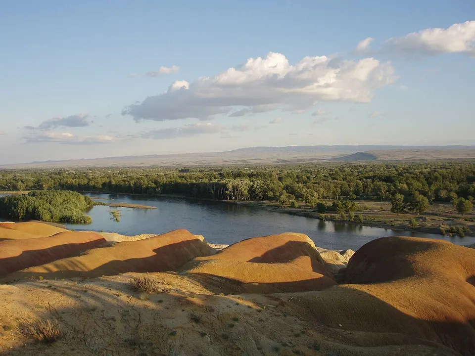
Birch woods, Kazakh pastures and the young Irtysh below the Altai
- Type
- Prefecture
- Region
- Xinjiang
- Featured places
- 1
- Listed sites
- 142 rated 5A · 12 rated 4A · 3 national heritage
About Altay
Altay is Xinjiang's northern tip, where larch and birch forest, rivers and summer pastures climb towards the Altai Mountains on the borders of Kazakhstan, Russia and Mongolia; Kazakhs make up about half its people. Kanas Lake, deep in the mountains, is its best-known sight, and the young Irtysh River runs through the granite gorge of Koktokay. Downstream lie the eroded colours of Wucaitan, and Bronze Age stone figures stand on the steppe around Chemurchek.
Featured places in Altay
-
Kanas Lake 喀纳斯湖
A milky-turquoise lake in the Altai forests that turns gold each autumn
Listed sites in Altay
14 sites in Altay are on the official lists. Those with a page of their own link to it; the rest open as cards on the map.
- Baisha Lake 白沙湖 5A scenic area · on the map
A small freshwater lake ringed by pale sand dunes at the Bingtuan's 185th Regiment in the far north-west of Habahe County, about 2.5 km from the Kazakhstan border. - Koktokay Scenic Area 可可托海 5A scenic area · 4A scenic area · on the map
A 788 km² 5A scenic area around Koktokay in the Altai, centred on the Irtysh Grand Canyon, where the young Irtysh River runs through forest past waterfalls, striking rock formations and the peak known as Divine Bell Mountain. - Agonggaiti Grassland Stone Figures Park 阿贡盖提草原石人 4A scenic area · on the map
A Kazakh culture park on the Agonggaiti grassland beside the road from Burqin to Kanas, built around a group of ancient steppe stone figures and rock carvings left by early nomads. - Altay Birch Park 桦林公园 4A scenic area · on the map
A park of wooded river islands at the north-western corner of Altay city, where the Kelan River splits into six islands under birch and poplar. - Fuyun Riverside Scenic Area 富蕴滨河 4A scenic area · on the map
A landscaped riverside promenade along the Irtysh in Fuyun county town, rated 3A in 2016 and 4A in 2019. - Grassland Stone City and Tongtiandong Cave 草原石城 4A scenic area · National heritage site · on the map
A 59 km² stretch of the Saur Mountain foothills south-east of Jeminay where weathering has shaped the granite into rounded boulders, stacks, basins, hollows and caves rising out of grassland, with more than 200 kinds of wild flowers in spring and early summer. - Habahe Birch Forest 哈巴河白桦林 4A scenic area · on the map
A belt of natural birch forest along the Habahe River valley just west of Habahe town, rated a national forest park in 2010 and linked to the town by the Akqi national wetland. - Kelan River Riverside Scenic Area 克兰河滨河 4A scenic area · on the map
An 11.6 km riverside scenic belt of about 720 hectares along the Kelan River through Altay city, from the Birch Park bridge in the north to the Red Stone area in the south. - Koktokay Rare Metals National Mine Park 可可托海国家矿山公园 4A scenic area · on the map
A former rare-metal mine in Koktokay town, built around the huge open pit of the Number 3 Vein, a deposit found in 1935 that is known as a natural geological museum for its 84 minerals, including lithium, beryllium, tantalum, niobium and caesium. - Sandaohaizi Stone Mounds and Deer Stones 三道海子 4A scenic area · National heritage site · on the map
A high basin of three lakes, Bianhaizi, Zhonghaizi and Huahaizi, at about 2,700 m on the Altai watershed near the Mongolian border, where summer pastures hold a Bronze Age landscape of giant stone mounds, tombs and deer stones. - Sino-Russian Old Wharf Street 中俄老码头风情街 4A scenic area · on the map
A riverside leisure quarter of about 20 hectares on the Irtysh in Burqin town, built around the old wharf of the Sino-Soviet river shipping that once ran on the Irtysh. - Ulungur Lake Golden Coast 乌伦古湖黄金海岸 4A scenic area · on the map
A sandy beach resort on the north-eastern shore of Ulungur Lake, with clear water, a shallow stretch about 100 m wide and water of around 20–22°C in summer. - Wucaitan (Five-Colour Beach) 五彩滩 4A scenic area · on the map
A stretch of the north bank of the Irtysh 24 km from Burqin, where water and wind have carved the ground into multicoloured ridges, gullies and pinnacles, facing the green riverine woods on the far bank. - Chemurchek Stone Figures and Stone-Cist Tombs 切木尔切克石人及石棺墓群 National heritage site
A Bronze Age burial ground of the Chemurchek culture, of about 2700–1800 BC, spread over some 44 km² of steppe around Chemurchek town west of Altay city, with large stone-walled grave enclosures, cairns ringed with stones and stone cists.
Getting to Altay
Train, flight and driving times from the cities most visitors come from, with stations, fares and how many run a day; each opens the full comparison.
- Ürümqi 乌鲁木齐 to Burqin · a nonstop route is listed
On the map
Open Altay on the illustrated map to see its outline, its places and listed sites together, and to add them to a trip.
Open Altay on the map