 Atlas of China
Changde 常德Chángdé
Tao Yuanming's Peach Blossom Spring and a walled town 6,000 years old
About Changde
Changde lies on the Yuan River at the western edge of Dongting Lake, and its three-kilometre flood wall along the river is carved with poems and calligraphy. In Taoyuan County, the Taohuayuan scenic area takes its name from Tao Yuanming's fable The Peach Blossom Spring, about a hidden valley cut off from the world. On the plain of Li County, Chengtoushan was ringed by a rammed-earth wall and moat around 4000 BC, beside some of the earliest dated rice paddies in the world.
What to eat in Changde
- Changde beef rice noodles (常德牛肉粉)
- Sauce-braised flat duck (酱板鸭)
Listed sites in Changde
22 sites in Changde are on the official lists. Those with a page of their own link to it; the rest open as cards on the map.
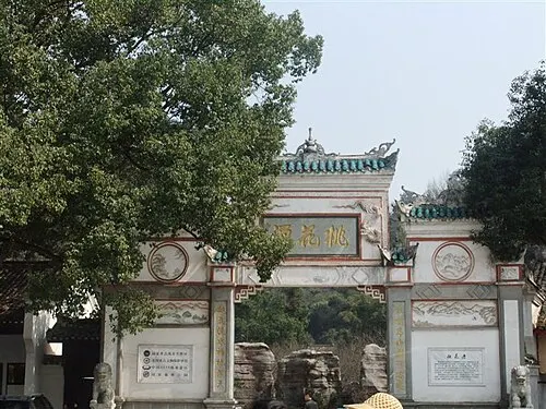
- Taohuayuan (Peach Blossom Land) 桃花源 5A scenic area · National heritage site
Taohuayuan, facing the Yuan River about 15 km south-west of Taoyuan county town, is the place long identified with Tao Yuanming's fable The Peach Blossom Spring, and temples and Daoist halls have stood here since the Tang. - Changde Planning Exhibition Hall 常德市规划展示馆 4A scenic area · on the map
The city's urban planning museum, run by the Changde natural resources and planning bureau and open since 2013, presents Changde's history, culture and planned growth in a series of themed sections. - Changde Wildlife World 常德野生动物世界 4A scenic area · on the map
A large zoo and safari-style park of about 2,500 mu (170 ha) in Hanshou County, opened in 2022, which now keeps more than 7,000 animals of over 200 species, among them Asian elephants, Siberian tigers, African lions and pumas. - Chengtoushan Archaeological Site Park 城头山遗址 4A scenic area · National heritage site
Chengtoushan, on the Liyang plain north-west of Li County town, is a round Neolithic town about 325 m across inside a rammed-earth wall and moat that were first built in the Daxi culture more than 6,000 years ago and enlarged several times before the town was abandoned around 4,000 years ago. - Fenglin Flower Sea, Taoyuan 枫林花海 4A scenic area · on the map
A flower-field park of about 2,000 mu (130 ha) in Weihui New Village, in the Fengshu Uyghur and Hui Ethnic Township, with large seasonal flower fields and a vineyard. - Former Residence of Lin Boqu 林伯渠故居 4A scenic area · National heritage site · on the map
The birthplace of Lin Boqu (1886–1960), a member of the Tongmenghui and of the Chinese Communist Party from 1921, who chaired the Shaan-Gan-Ning Border Region government, was secretary-general of the Central People's Government and later vice-chairman of the NPC Standing Committee, and is counted among the 'Five Elders' of Yan'an. - Huayanxi National Forest Park 花岩溪 4A scenic area · on the map
A national forest park designated in 1997 at the northern foot of the Jiulong Mountains, an offshoot of the Xuefeng range, where Dingcheng, Taoyuan and Anhua meet, covering about 75 km² of wooded hills and streams. - Jiashan Temple 夹山寺 4A scenic area · National heritage site · on the map
A Chan Buddhist monastery in Jiashan National Forest Park, founded in 870 by the monk Shanhui and known from the Song to the Qing as Lingquan Chan Monastery; the Song master Yuanwu Keqin is said to have taught here the koan commentaries collected as the Blue Cliff Record, and the temple is promoted as a cradle of 'tea and Chan' culture. - Kale Planet Theme Park, Changde 常德卡乐星球 4A scenic area · on the map
A theme park on Peach Blossom Island in Liuye Lake, opened in January 2020 and built by the culture-tourism technology arm of the OCT (Overseas Chinese Town) group together with Changde's city investment company. - Lingxi Camellia Oil Estate, Jinshi 灵犀茶油庄园 4A scenic area · on the map
A camellia-oil estate on the shore of Maoli Lake in Jinshi, run by a local camellia-oil producer, that has been developed into a leisure and wellness area; provincial media describe it as Hunan's first eco-wellness estate built around camellia oil. - Liuye Lake Tourist Resort 柳叶湖 4A scenic area · on the map
Liuye Lake, a lake of about 17.6 km² on the north-eastern edge of Changde, is the centre of a tourist resort set up in 1993, rated 4A in 2010 and named a national-level tourist resort in 2020. - Longwang Cave, Shimen 龙王洞 4A scenic area · on the map
A limestone cave in Baiyun town, Shimen County, beside the waters of the Xianyang Lake national wetland park, opened to visitors in 1988 as the county's first tourist site. - Pengshan Scenic Area, Li County 彭山 4A scenic area · on the map
A forested hill area in Linan town, across the Li River from Li County town, rated 4A and listed as a national forest-wellness pilot base. - Duo'an Bridge 多安桥 National heritage site · on the map
An eleven-arch stone bridge 211 m long across the Dan River outside the east gate of old Lizhou, first built in 1786 and rebuilt after flood damage in 1820–1821. - Huawa Temple Pagoda 花瓦寺塔 National heritage site · on the map
A Northern Song brick pagoda in Huawa village in the far north of Li County, octagonal and solid, rising seven storeys and about 22 m from a base about 5.5 m across. - Iron Sutra Pillar, Changde 常德铁幢 National heritage site
A hollow cast-iron Buddhist sutra pillar of the Northern Song, about 4.3 m tall and weighing some 1.5 tonnes, which stood beside Qianming Temple at Deshan until it was moved to Binhu Park in central Changde in 1979. - Lizhou Ancient City Wall 澧州古城墙 National heritage site · on the map
The surviving south-eastern stretch, about 1.9 km long, of the wall of Lizhou, the prefectural city that became Li County town; it was raised in rammed earth in 1372, when the seat moved here, faced with brick in 1404 and repaired many times under the Ming and Qing. - Lizhou Confucian Temple 澧州文庙 National heritage site · on the map
The temple of the former Lizhou prefectural school, founded in 965, moved to this site in the early Ming and rebuilt in 1841–1844, covering about 8,000 m². - Nanchanwan Jin Tombs (Tomb of Liu Hong) 南禅湾晋墓群 National heritage site · on the map
A group of Warring States settlement remains, Jin-to-Tang kilns and tombs in Huangshantou Forest Park, best known for the tomb of Liu Hong, the Western Jin general and governor of Jingzhou, excavated in 1991. - Shimen Confucian Temple 石门文庙 National heritage site · on the map
The county Confucian temple of Shimen, founded in 1052 and moved in 1504 to this site near the north bank of the Li River, with most of its present buildings from Qing rebuilding. - Xingzi Palace 星子宫 National heritage site · on the map
A Daoist temple complex on the summit of Xingzi Mountain in Reshi town, founded in 1370 by the Daoist Zhang Daohui as the Sanyuan Palace, renamed after the mountain and enlarged in the late Ming and early Qing and again in 1784, 1807 and 1829. - Yu Family Memorial Arch 余家牌坊 National heritage site · on the map
A white-marble chastity arch about 15 m high and 8 m wide in Pailou village, completed in 1842 by the official Yu Yuechan in honour of his mother, née Luo, who was widowed at 24.
On the map
Open Changde on the illustrated map to see its outline, its places and listed sites together, and to add them to a trip.
Open Changde on the map