 Atlas of China
Shiyan 十堰Shíyàn
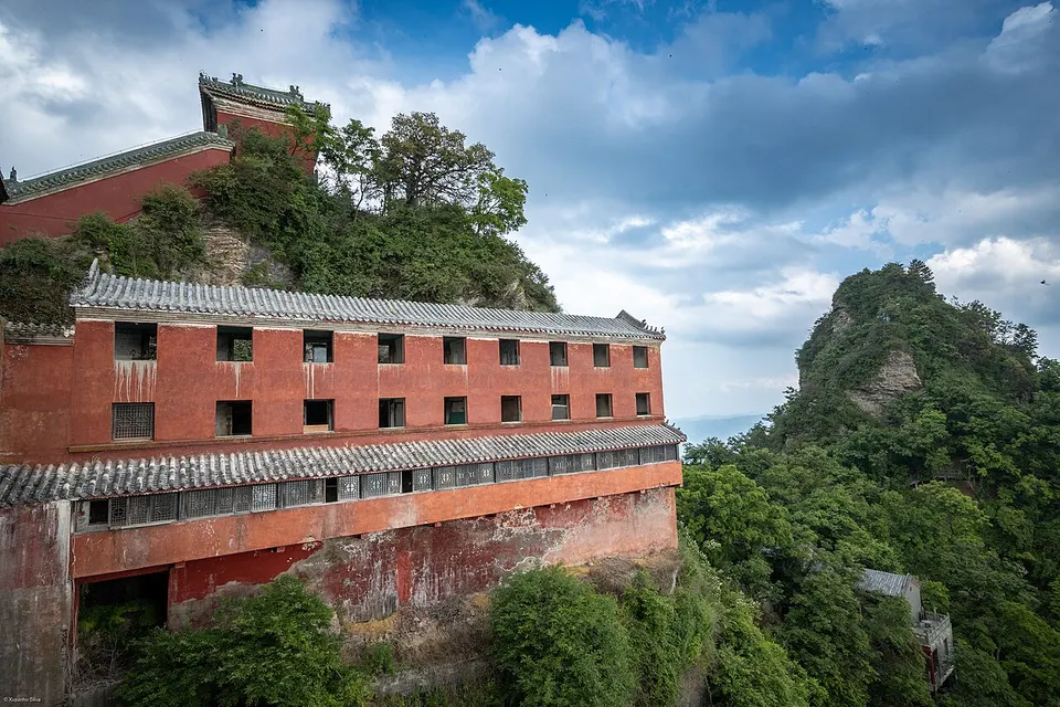
Taoist palaces on Wudang's peaks, above a city built around a truck works
About Shiyan
Shiyan was a small town until the Second Automobile Works, today's Dongfeng Motor, was built in its valleys from 1969. Its great draw is the Wudang Mountains, a Taoist range of Ming palaces and temples climbing to the Golden Hall on the summit, famous for Wudang martial arts and a World Heritage site. To the east, the Danjiangkou Reservoir on the Han River feeds the central route of the South–North Water Transfer, which carries water to Beijing.
Featured places in Shiyan
-
Wudang Mountains 武当山
Taoist palaces strung along forested ridges, and the legendary birthplace of tai chi
Listed sites in Shiyan
29 sites in Shiyan are on the official lists. Those with a page of their own link to it; the rest open as cards on the map.
- Bailongtan Scenic Area 百龙潭 4A scenic area · on the map
A wooded stream valley with a canyon walkway on the western edge of Shiyan, in Zhangwan District. - Canglanghai, Danjiangkou 沧浪海 4A scenic area · on the map
A lakeside leisure area and boat landing on Danjiangkou Reservoir, in the new district at the edge of Danjiangkou city. - Donggou Red Tourism Area 东沟红色旅游景区 4A scenic area · on the map
A red-tourism area in Donggou village, Maota township, in the hills south of Shiyan, centred on a restored Ming–Qing house that holds the Central Plains Breakout (Northwest Hubei) History Memorial Hall. - Guanyin Cave, Fangxian 观音洞 4A scenic area · on the map
A small temple-and-cave site on a hill about 3 km south of Fangxian county town. - Hanjiang Green Valley 汉江绿谷 4A scenic area · on the map
A leisure area of about 6 km² in Anyang town, Yunyang, with a herb garden of about 330 hectares, a flower field on the water of over 60 hectares, more than 200 hectares of grassland and three themed 'manor' areas. - Honggan Ping Orange Orchard, Junxian 红甘苹橘海 4A scenic area · on the map
A commercial 'smart orchard' beside Danjiangkou Reservoir in Junxian town, run by the Honggan Ping company and rated 4A as an agri-tourism site. - Huxiaotan Gorge 虎啸滩 4A scenic area · on the map
A river-gorge scenic area on the Baiquan River in Baiquan village, Daliu township, named 'Tiger Roar Shoal' for the sound of the water pounding the rocks. - Jingle Palace, Danjiangkou 静乐宫 4A scenic area · on the map
A Taoist palace complex on the north shore of Jingle Lake, at the north-eastern edge of Danjiangkou city. - Jiulong Falls, Yunyang 郧阳九龙瀑 4A scenic area · on the map
A gorge scenic area in Nanhuatang town, Yunyang district, named 'Nine Dragons Falls' for the series of waterfalls along its stream; the district lists its core area as about 18 km². - Longtan River, Yunxi 郧西龙潭河 4A scenic area · on the map
A waterfall and gorge scenic area in Yangwei town, run as a provincial forest park and geopark, with more than sixty sights, over forty of them connected with waterfalls. - Nüwa Mountain, Zhushan 女娲山 4A scenic area · on the map
A mountain scenic area in Baofeng town built around the legend of Nüwa, the goddess who in Chinese myth mended the sky and made the first people. - Qinglongshan Dinosaur Egg Fossil Geopark 青龙山恐龙蛋化石群国家地质公园 4A scenic area · on the map
A national geopark in Liupi town protecting a field of Cretaceous dinosaur eggs left where they were laid, with at least 300,000 eggs estimated, which state media describe as the largest known in-situ concentration. - Shangjin Ancient City 上津古城 4A scenic area · National heritage site · on the map
A compact walled town on the east bank of the Jinqian River, close to the Shaanxi border, roughly 400 by 300 metres with walls about 7 m high, and known locally as the 'Emperor's Ferry' for its river crossing on the way towards Xi'an. - Shiyan Museum 十堰市博物馆 4A scenic area · on the map
The municipal museum of Shiyan, a national second-grade museum in the city centre close to Beijing North Road. - Taiji Gorge 太极峡 4A scenic area · on the map
A red-sandstone gorge on the western side of Danjiangkou Reservoir, in Shigu town. - Taohuadao Rammed-Earth Town 桃花岛夯土小镇 4A scenic area · on the map
A modern rural tourism town in Shuiping town, built in rammed-earth style from about 2018 and called Peach Blossom Island (Taohuadao); its Chinese name, Hangtu Xiaozhen, means 'rammed-earth town'. - Tianhe Scenic Area, Yunxi 郧西天河 4A scenic area · on the map
A riverside scenic area on the Tianhe at the southern edge of Yunxi county town, built around the county's Qixi (Double Seventh) culture, which is on China's national list of intangible cultural heritage. - Tianhekou, Yunxi 天河口 4A scenic area · on the map
The place where the Tianhe ('Heavenly River') flows into the Han, in Guanyin town, linked by local tradition to the Qixi (Double Seventh) legend of the cowherd and the weaver girl. - Wudang Daming Peak 武当大明峰 4A scenic area · on the map
A mountain scenic area in Guanshan town, west of the Wudang Mountains' main peak, which Shiyan's tourism commission puts at about 1,316 m in height and roughly 39 sq km in area. - Wudang Happy Valley 武当山快乐谷 4A scenic area · on the map
A commercial adventure and amusement park in a wooded river valley in the Wudang Special Zone, about 5 km from the entrance of the Wudang Mountains scenic area and next to Taiji Lake. - Wudang South Pilgrim Path 武当山南神道 4A scenic area · on the map
A walking-oriented scenic area on the south-western flank of the Wudang Mountains in Guanshan town, on the old pilgrim route by which worshippers from Sichuan, Shaanxi and western Hubei once came to Wudang. - Wulong River Scenic Area 五龙河 4A scenic area · on the map
A forested gorge scenic area on the Wulong River, a tributary of the Tianhe that rises in the Qinling foothills on the Hubei–Shaanxi border, nicknamed 'little Jiuzhaigou' locally for its clear water, waterfalls and woods. - Yeren Cave and Valley, Fangxian 野人洞·野人谷 4A scenic area · on the map
A limestone cave and a wooded gorge about 25 km south of Fangxian county town, named after local 'wild man' (yeren) stories; the best known tells of a farmer's encounter at the cave mouth in 1974. - Yunlong Valley, Sai Wudang 赛武当云龙谷 4A scenic area · on the map
A large mountain-resort development in the Sai Wudang hills south of central Shiyan, in Maojian District, planned over about 24 km² in three phases with wellness, hot-spring, family-study, mountain-sports and folk-culture zones. - Zhushan Turquoise Culture Tourist Area 竹山绿松石文化旅游区 4A scenic area · on the map
A themed cultural-tourism complex in Zhushan county town, between the Du and Huo rivers, built around turquoise, which is mined in several counties of north-west Hubei including Zhushan, and around local legends and history, from the Nüwa myth to the ancient Yong state and the Peach Blossom Spring story. - Cixiaogou Imperial Timber Cliff Inscription 慈孝沟“采皇木”摩崖 National heritage site · on the map
A small Ming-dynasty rock inscription in a gorge in Eping township, carved in 1558 on a cliff to mark the felling of giant nanmu timbers that were sent to Beijing to build the imperial palace. - Dafeng Granary, Yunyang 大丰仓 National heritage site · on the map
A Qing-dynasty state granary in the old town of Yunyang, on a rise beside the bridgehead of the Yunyang Han River Bridge, rebuilt in 1881 on the site of an earlier prefectural granary. - Gan Ancestral Hall, Zhuxi 甘氏宗祠 National heritage site · on the map
A Qing-dynasty clan ancestral hall in Ganjialing village, Zhongfeng town, built in memory of Gan Jifang, a local garrison officer of the early Qing, and enlarged in the mid-18th and late 19th centuries. - Gaojia Huawu 高家花屋 National heritage site · on the map
A Qing-dynasty family residence in Xiejiagou village, Zhuping township, in the hills of north-west Zhushan county near the Hubei–Shaanxi–Sichuan border.
On the map
Open Shiyan on the illustrated map to see its outline, its places and listed sites together, and to add them to a trip.
Open Shiyan on the map