 Atlas of China
Luoping Rapeseed Fields 罗平油菜花海Luópíng Yóucàihuā Hǎi
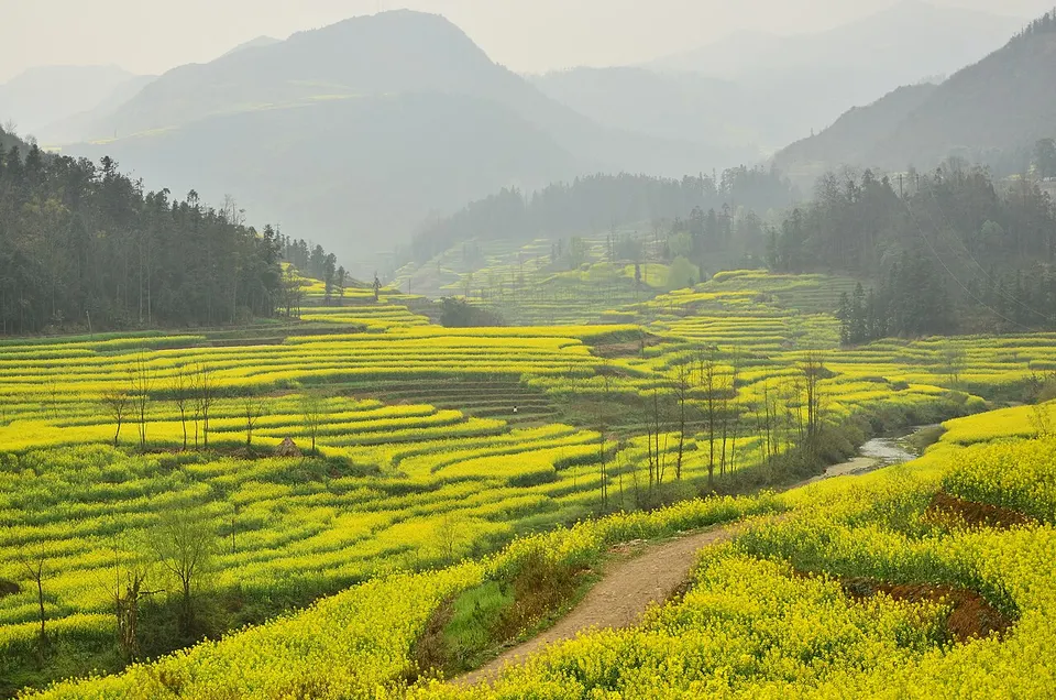
Seas of golden rapeseed flowers swirling around karst peaks and spiral terraces
- Best time
- Late Feb–mid-Mar
- Time needed
- 1–2 days
- Days to budget
- 2 days
- Stay in
- Luoping
- Region
- Yunnan
- Type
- Nature
- Listed as
- 4A scenic area
Why go to Luoping Rapeseed Fields
Each late winter the farmland around Luoping, in eastern Yunnan, turns gold as rapeseed comes into flower across a vast area. At Jinjifeng, hundreds of small conical karst hills rise from the yellow fields, while at Niujie the crops curl around sinkholes in concentric 'snail shell' terraces. North-east of town, the Jiulong Waterfalls tumble down a staircase of ten falls in a Bouyei farming valley.
The story
The rapeseed is grown for cooking oil, and the blossom also feeds beekeepers' hives: Luoping rapeseed honey carries a national geographical-indication label. Luoping is a heartland of the Bouyei people, whose spring festivals bring antiphonal singing, dancing and bamboo-raft races.
What to see at Luoping Rapeseed Fields
- Jinjifeng Peaks 金鸡峰丛: Hundreds of small cone-shaped karst hills set among the rapeseed fields, a cluster usually reached by a short climb to a viewing platform. It lies roughly 12 km from Luoping town.
- Niujie Spiral Fields 牛街螺丝田: Terraced fields that wind in concentric rings around sinkholes, so that the crops look like the thread of a screw. A roadside viewpoint overlooks them.
- Jiulong Waterfalls 九龙瀑布群: A series of falls stepping down a river valley in Jiulong, a 4A scenic area. A calm place to cool off after the flower fields.
- Duoyi River 多依河: A river about 12 km long with close to 40 small tufa-edged falls, flowing through a Buyi farming area. Bamboo-raft rides are the usual way to see it, and it is lower and warmer than the rest of the county.
How to visit Luoping Rapeseed Fields
Plan the day by direction rather than as one loop: Jinjifeng and Niujie are the flower-season stops, Jiulong is on the north-east side of town, and Duoyi River lies roughly 40 km to the south-east. A hired car and driver ties these together most easily. A half day gets you the peaks and the spiral fields; a full day adds the waterfalls or the river, and outside the flower season the waterfalls and river are the better reasons to come.
How to get to Luoping Rapeseed Fields
Luoping is about 240 km east of Kunming: direct buses from Kunming East Bus Station take around 3.5 hours, and conventional trains (there is no high-speed link) take about 3–4 hours. The viewpoints lie 10–25 km from town, so hire a car and driver or use taxis.
Where to stay
Stay in Luoping town, which has the most rooms and restaurants and is the usual base for the viewpoints; during the flower festival, book early because the town fills up.
What to eat
- Five-colour flower rice 五色花米饭: Glutinous rice dyed with plant colours, a speciality of the local Buyi people.
- Bamboo-wrapped baba 竹裹粑粑: A Buyi sticky-rice cake wrapped and steamed in bamboo leaves.
- Luoping yellow ginger 小黄姜: Luoping's small yellow ginger, one of the county's 'three yellows' with rapeseed oil and honey, used in stews and sold as a local gift.
Tips for visiting Luoping Rapeseed Fields
- Bloom dates shift with the weather each year, so check current reports before you go, and book rooms early: the flower festival from late February fills the town.
- Be at the Jinjifeng viewing platform before dawn for sunrise and mist among the peaks; Niujie's spiral fields look best in afternoon light.
- The Jiulong Waterfalls run low in the spring dry season and are at their fullest in summer; mornings in flower season are chilly, so bring a jacket.
Nearby
- Puzhehei 普者黑 90 km
Lotus-filled lakes winding between hundreds of green karst hills, explored by boat - Stone Forest 石林 110 km
A maze of limestone blades and towers you can lose yourself in
Also within 30 km: Duoyi River 多依河 (20 km).
On the map
Open Luoping Rapeseed Fields on the illustrated map to see the terrain around it, what else is close, and to add it to a trip and plan the days.
Open Luoping Rapeseed Fields on the map