 Atlas of China
Karakul Lake & Karakoram Highway 喀拉库勒湖Kālākùlè Hú
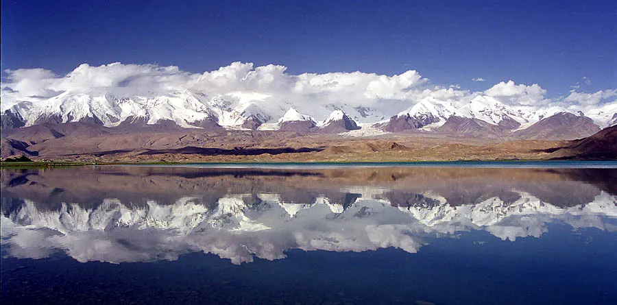
A still, high lake mirroring Muztagh Ata on the road to Pakistan
Why go to Karakul Lake & Karakoram Highway
Around 190 km from Kashgar on the Karakoram Highway, Karakul Lake lies at about 3,600 metres, its still water reflecting the snowy domes of Muztagh Ata and Kongur. Kyrgyz herders graze yaks and camels on the shores, and the highway runs on through the Pamirs to Tashkurgan and the Khunjerab Pass into Pakistan.
The story
Muztagh Ata is usually translated as 'father of ice mountains'. The Karakoram Highway, built jointly by China and Pakistan and completed in 1979, crosses the Khunjerab Pass at about 4,700 metres, one of the highest paved border crossings in the world.
What to see at Karakul Lake & Karakoram Highway
- Muztagh Ata and Kongur 慕士塔格峰与公格尔峰: Three peaks over 7,500 m rise above the lake: Muztagh Ata at 7,546 m, Kongur Tagh and Kongur Tiube, best in the morning light.
- Lakeshore Kyrgyz settlements 吉尔吉斯定居点: A few yurts about 1 km east of the bus drop-off and a stone-house village on the western shore, where herding families live in summer.
- Camel and horse rides 骑骆驼骑马: Short rides along the shore are on offer from local Kyrgyz families.
- Lakeshore walk 环湖步行: A walk along the shore and boardwalk takes a few hours, with small streams to hop over.
- Karakoram Highway drive 喀喇昆仑公路: The road to the lake climbs through high valleys with herders and villages, and the drive is part of the draw.
How to visit Karakul Lake & Karakoram Highway
Most visitors reach the lake by car or bus along the Karakoram Highway and get out at the shore near the bus drop-off. Spend a few hours walking the shore or taking a short ride and look back at the peaks; if you stay overnight in a yurt you will see the stars and the dawn light on the peaks. At 3,600 m, go slowly.
How to get to Karakul Lake & Karakoram Highway
It's roughly four hours by road from Kashgar; most visitors hire a car and driver and continue to Tashkurgan for the night.
Where to stay
Basic stays are available in Kyrgyz yurts and huts by the lake, but they are simple and cold at night; bring a sleeping bag. Others return to Kashgar or continue to Tashkurgan.
What to eat
- Salty milk tea 奶茶: Hot milk tea, salted, a staple of the Kyrgyz and Tajik herding families around the lake.
- Flatbread 馕: Round bread baked in the Kyrgyz and Uyghur style, eaten with every meal; some homestays offer a bread-making session.
Tips for visiting Karakul Lake & Karakoram Highway
- Foreign visitors need a border-area permit, usually arranged in Kashgar or through an agency, and passports are checked at the highway checkpoints.
- Acclimatise in Kashgar first and take it easy at 3,600 m.
- Bring warm layers: the wind off the lake is cold even in summer, and nights at this altitude drop below freezing.
Trips with Karakul Lake & Karakoram Highway
- Xinjiang: Ürümqi, Turpan, Kashgar, Karakul Lake and Kanas 11 days · Ürümqi, Turpan, Kashgar and Burqin
On the map
Open Karakul Lake & Karakoram Highway on the illustrated map to see the terrain around it, what else is close, and to add it to a trip and plan the days.
Open Karakul Lake & Karakoram Highway on the map