 Atlas of China
Taohuajian and the General Cliff Petroglyphs 桃花涧·将军崖岩画Táohuājiàn · Jiāngjūnyá Yánhuà
4A scenic area · National heritage site · Lianyungang, Jiangsu
- Time needed
- Half a day
- Days to budget
- Half a day
- City
- Lianyungang
- Region
- Jiangsu
- Type
- Heritage
- Listed as
- 4A scenic area, National heritage site
About Taohuajian and the General Cliff Petroglyphs
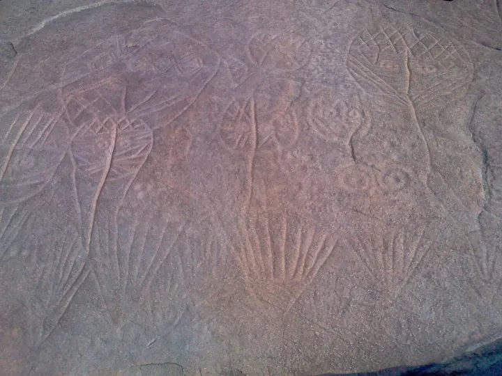
A wooded valley on the southern slopes of Jinping Mountain, south-west of Haizhou, with a stream, pools and paths up to a summit viewpoint; its western part holds the General Cliff petroglyphs. Carved into a sloping rock face, they show human faces linked to plant-like lines, star symbols and animals, and archaeologists read them as a prehistoric farming ritual site of the Dongyi people. Micro-erosion dating suggests the carvings were made over a long span, between about 10,000 and 3,000 years ago.
How to get to Taohuajian and the General Cliff Petroglyphs
In Jinping town about 14 km south-west of central Lianyungang, around 30 minutes by taxi.
Nearby
Also within 20 km: Kongwang Mountain 孔望山 (under 10 km), Lianyungang Museum 连云港市博物馆 (10 km), Lianyungang Revolutionary Memorial Hall 连云港市革命纪念馆 (10 km), Mount Huaguo 花果山 (20 km), Haiqing Temple Pagoda 海清寺塔 (20 km).
On the map
Open Taohuajian and the General Cliff Petroglyphs on the illustrated map to see the terrain around it and what else is close, and to add it to a trip.
Open Taohuajian and the General Cliff Petroglyphs on the map